Latitude: 55.1089 / 55°6'31"N
Longitude: -1.6722 / 1°40'19"W
OS Eastings: 421011
OS Northings: 579432
OS Grid: NZ210794
Mapcode National: GBR J9RC.SF
Mapcode Global: WHC2Y.8VZC
Plus Code: 9C7W485H+G4
Entry Name: Churchyard Cross 15 Metres North East of Church of St Mary
Listing Date: 29 April 1987
Grade: II
Source: Historic England
Source ID: 1370787
English Heritage Legacy ID: 239003
ID on this website: 101370787
Location: St Mary's Church, Stannington, Northumberland, NE61
County: Northumberland
Civil Parish: Stannington
Built-Up Area: Stannington
Traditional County: Northumberland
Lieutenancy Area (Ceremonial County): Northumberland
Church of England Parish: Stannington St Mary the Virgin
Church of England Diocese: Newcastle
Tagged with: Churchyard cross
This List entry was subject to a Minor amendment on 24/05/2016.
NZ 27 NW
8/98
STANNINGTON
CHURCH ROAD
(South side)
Churchyard cross 15 metres north-east of Church of St. Mary
(Formerly listed as: CHURCH LANE)
II
GV
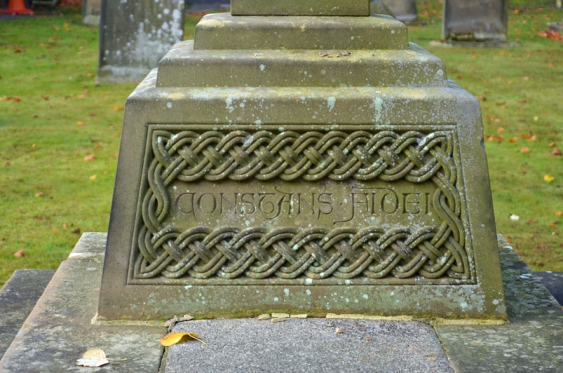
Churchyard cross, c.1890. Given by Viscount Ridley. Ashlar; enclosing wall
tooled ashlar. 5 steps up to raised rectangular platform with tall Celtic
cross at west end. Interlace ornament; east side of base inscribed CONSTANS.
FIDEI. Low enclosing wall with angle pilasters and chamfered coping.
Listing NGR: NZ2101179432
External links are from the relevant listing authority and, where applicable, Wikidata. Wikidata IDs may be related buildings as well as this specific building. If you want to add or update a link, you will need to do so by editing the Wikidata entry.


Other nearby listed buildings