Latitude: 55.3776 / 55°22'39"N
Longitude: -1.8158 / 1°48'56"W
OS Eastings: 411772
OS Northings: 609306
OS Grid: NU117093
Mapcode National: GBR H6R8.P3
Mapcode Global: WHC1Q.23M9
Plus Code: 9C7W95HM+2M
Entry Name: Disused Railway Viaduct 200 Metres North East of Edlingham Castle
Listing Date: 25 August 1987
Grade: II
Source: Historic England
Source ID: 1372288
English Heritage Legacy ID: 236452
ID on this website: 101372288
Location: Edlingham, Northumberland, NE66
County: Northumberland
Civil Parish: Edlingham
Traditional County: Northumberland
Lieutenancy Area (Ceremonial County): Northumberland
Church of England Parish: Whittingham and Edlingham with Bolton Chapel
Church of England Diocese: Newcastle
Tagged with: Architectural structure Railway viaduct
EDLINGHAM EDLINGHAM VILLAGE
NU 10 NW
14/328 Disused railway
viaduct 200 metres
north-east of
Edlingham Castle
GV II
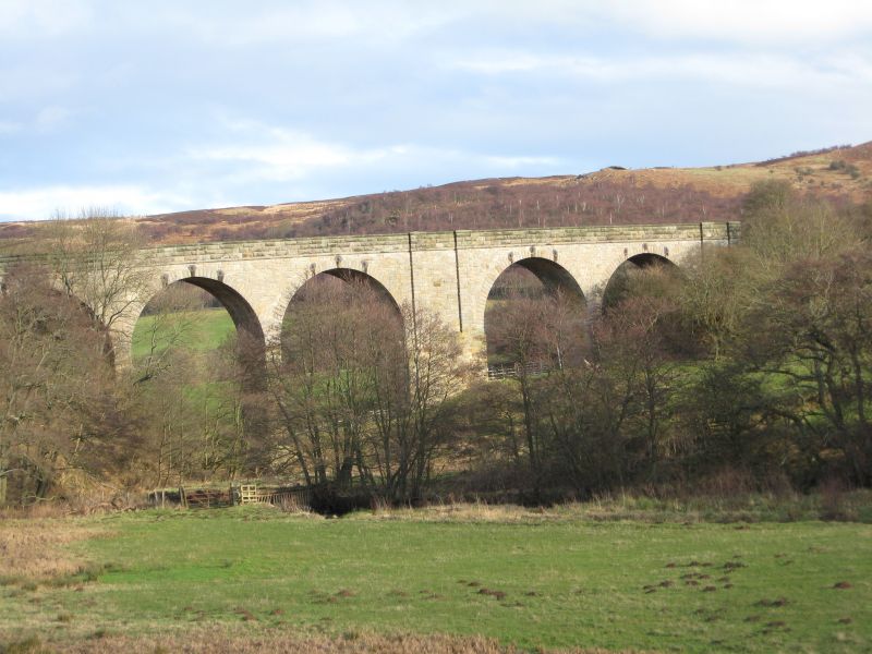
Railway viaduct, c.1885. Snecked stone except for lower part of pier between
sections, which is heavy roughly-squared stone; rock-faced dressings and
parapet, rock-faced-and-margined voussoirs; soffits of arches brick. South
elevation 3 + 2 round arches on tall tapering piers; reinforcing ties above
arches; paired pilasters at ends and on broad pier between sections. Band
below parapet which has chamfered coping.
Part of the North Eastern Railway's Alnwick to Coldstream (Cornhill) branch
built under the Alnwick and Cornhill Act of May 1882 and opened in 1887.
Landscape value.
Listing NGR: NU1177209306
External links are from the relevant listing authority and, where applicable, Wikidata. Wikidata IDs may be related buildings as well as this specific building. If you want to add or update a link, you will need to do so by editing the Wikidata entry.


Other nearby listed buildings