Approximate Location Map
Large Map »
Latitude: 53.8228 / 53°49'22"N
Longitude: -1.5795 / 1°34'46"W
OS Eastings: 427780
OS Northings: 436365
OS Grid: SE277363
Mapcode National: GBR B99.BD
Mapcode Global: WHC9C.Q52P
Plus Code: 9C5WRCFC+46
Entry Name: Numbers 79, 81, 83 and 83A and Attached Outbuildings
Listing Date: 24 May 1990
Grade: II
Source: Historic England
Source ID: 1375307
English Heritage Legacy ID: 466202
ID on this website: 101375307
Location: Far Headingley, Leeds, West Yorkshire, LS6
County: Leeds
Electoral Ward/Division: Headingley
Parish: Non Civil Parish
Built-Up Area: Leeds
Traditional County: Yorkshire
Lieutenancy Area (Ceremonial County): West Yorkshire
Church of England Parish: Headingley St Michael
Church of England Diocese: Leeds
Tagged with: Terrace of houses
LEEDS
SE2736SE OTLEY ROAD, Headingley
714-1/61/810 (West side)
24/05/90 Nos.79, 81, 83 AND 83A
and attached outbuildings
II
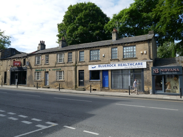
Row of houses, now offices, including shop, with outbuildings
attached to north. Early C19 with late C19 alterations,
outbuildings probably C18; refurbished and altered c1993.
Houses of coursed gritstone rubble with grey slate roof, eaves
band, moulded gutter brackets, gable copings, 4 stone ridge
stacks, that to right end reduced in height; outbuildings of
squared and coursed rubble with stone slate roofs, gable
coping right, brick stack to corner of single-storey section,
rear.
Houses: 2 storeys and basement, first-floor band, 8
first-floor windows: sashes with glazing bars, alternate
windows tripartite sashes; far right altered to paired
plate-glass sashes in plain stone surround. Ground floor: the
original design of 2 mirrored pairs of houses is clear to
centre and left, each with a tripartite sash and 6-panel door
and overlight in plain stone surround with tie-stone jambs,
the 2 centre doors blocked and the entrance far left (No.79)
having 2 stone steps. To right of centre (No.81): original
doorway blocked and entrance with stone steps inserted
immediately to left, plain jambs, door and overlight as No.79.
Right: late C20 shop entrance and window. Lintels of basement
windows at street level centre and left. Rear: an original
small-pane window to first floor, left of centre; other
windows enlarged.
Outbuilding range, road frontage: small C19, early C20 shop
door and window far left, single-storey and taller block to
right with inserted shop facade, coursing runs through with
breaks on roof-truss line to right of centre on single-storey
block, and to left of centre on taller block.
Rear: 4 different building uses are suggested by the style of
this range, from left to right: i) 2-storey, 3-bay barn, the
right bay breaks forward slightly; built of large squared
blocks with herringbone tooling, blocked cart entrance left,
other altered later openings, small square loading door in
gable left return; ii) 2-storey, 2-bay stable/cottage,
openings altered on ground floor, square opening above; iii)
single-storey 4-bay stable/byre, possibly a smithy, brick
stack to eaves left, small-paned window; iv) taller
single-storey outbuilding.
INTERIOR: not inspected.
HISTORICAL NOTE: the land was owned by the Earls of Cardigan
in the C18, the outbuildings were possibly built as a
smallholding encroachment on the road edge, several enclosures
are shown on the west side of the Otley Road in 1834 (Baines
and Newsome), in an area otherwise sparsely populated. The row
of houses was possibly a building speculation by the Earl of
Cardigan, the style being similar to estate housing of the
period, the earlier buildings retained as outbuildings. The
alterations from 4 small houses to 3 probably took place soon
after construction, as by 1846 (Tithe Award) the land was
described as 3 houses, garden and outbuildings, part owned by
Henry Mitchell, architect (?designer), Windsor Charlesworth
and the Earl of Cardigan. In the same year the land was sold
to the Headingley Turnpike Trust. Shops were inserted by the
end of the C19 and included W Abbey and Sons, seedsmen, who
cultivated the gardens behind, employees living in the houses.
(Baines and Newsome: Map of Leeds: 1834-; Douglas, J
(Victorian Society): pers. comm.).
Listing NGR: SE2778036365
External links are from the relevant listing authority and, where applicable, Wikidata. Wikidata IDs may be related buildings as well as this specific building. If you want to add or update a link, you will need to do so by editing the Wikidata entry.


Other nearby listed buildings
