Latitude: 53.1921 / 53°11'31"N
Longitude: -2.868 / 2°52'4"W
OS Eastings: 342105
OS Northings: 366463
OS Grid: SJ421664
Mapcode National: GBR 7B.2ZVK
Mapcode Global: WH88F.X1G6
Plus Code: 9C5V54RJ+RR
Entry Name: Milepost 50 Metres East of Boughton Gyratory
Listing Date: 23 July 1998
Grade: II
Source: Historic England
Source ID: 1375940
English Heritage Legacy ID: 469919
ID on this website: 101375940
Location: Boughton, Cheshire West and Chester, Cheshire, CH3
County: Cheshire West and Chester
Electoral Ward/Division: Boughton
Parish: Non Civil Parish
Built-Up Area: Chester
Traditional County: Cheshire
Lieutenancy Area (Ceremonial County): Cheshire
Church of England Parish: Chester St Paul
Church of England Diocese: Chester
Tagged with: Milestone
CHESTER CITY (EM)
SJ4166 TARVIN ROAD
1932-1/6/270 (North side)
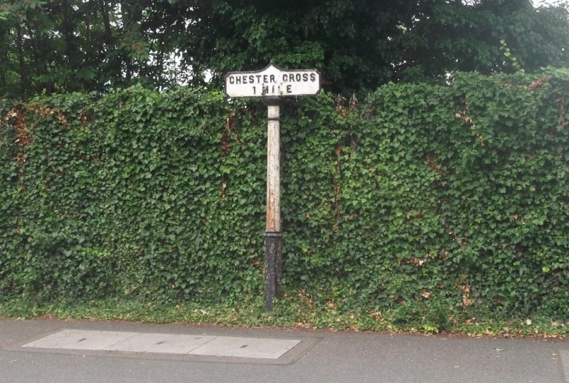
Milepost 50 metres east of Boughton
gyratory
II
Milepost. c1900. Made by RT Smith and Co. of Whitchurch,
Salop. Cast-iron. Plinthed slightly tapered octagonal post
approx 2 metres high carries a shaped plate inscribed in
raised capitals CHESTER CROSS: 1 MILE. One of a set of posts
erected by Chester City Council 1900 to 1903 on main access
routes to Chester.
Listing NGR: SJ4210566463
External links are from the relevant listing authority and, where applicable, Wikidata. Wikidata IDs may be related buildings as well as this specific building. If you want to add or update a link, you will need to do so by editing the Wikidata entry.


Other nearby listed buildings