Approximate Location Map
Large Map »
Latitude: 53.1855 / 53°11'7"N
Longitude: -2.8901 / 2°53'24"W
OS Eastings: 340614
OS Northings: 365752
OS Grid: SJ406657
Mapcode National: GBR 7B.36GZ
Mapcode Global: WH88F.K6Y7
Plus Code: 9C5V54P5+6W
Entry Name: Retaining Wall to Bank of River Dee Opposite County Hall (Not Included)
Listing Date: 6 August 1998
Grade: II
Source: Historic England
Source ID: 1376110
English Heritage Legacy ID: 470100
ID on this website: 101376110
Location: Chester, Cheshire West and Chester, Cheshire, CH4
County: Cheshire West and Chester
Civil Parish: Chester Castle
Built-Up Area: Chester
Traditional County: Cheshire
Lieutenancy Area (Ceremonial County): Cheshire
Church of England Parish: Chester St John the Baptist
Church of England Diocese: Chester
Tagged with: Retaining wall
CHESTER CITY (IM)
SJ4065NE CASTLE DRIVE
595-1/6/84 (South side)
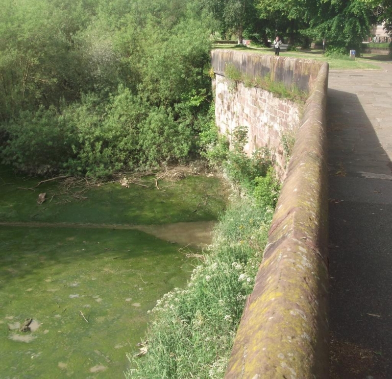
Retaining wall to bank of River Dee
opposite County Hall (not included)
GV II
Wall with parapet. c1830. Coursed sandstone. The south face
towards the tidal River Dee is approx 15 courses capped by a
roll-mould. The ground north of the wall is level with the
mould. The parapet is of stone slabs approx one metre wide x
one metre high jointed in iron and with some iron cramps.
The wall was probably built by the Council of the County
Palatine of Chester when they bought the land between the
County gaol and the river c1830. The east portion was modified
c1913 in connection with building the City Council's
hydro-electric station.
(Bartholomew City Guides: Harris B: Chester: Edinburgh: 1979-:
133-4; Wood: Map of Chester: Chester: 1833-; Ordnance Survey,
1:2500 Plans, First Edition: Wood: Chester City: 1875-).
Listing NGR: SJ4061465752
External links are from the relevant listing authority and, where applicable, Wikidata. Wikidata IDs may be related buildings as well as this specific building. If you want to add or update a link, you will need to do so by editing the Wikidata entry.


Other nearby listed buildings
