Approximate Location Map
Large Map »
Latitude: 53.1886 / 53°11'19"N
Longitude: -2.8926 / 2°53'33"W
OS Eastings: 340454
OS Northings: 366097
OS Grid: SJ404660
Mapcode National: GBR 79.35W0
Mapcode Global: WH88F.J3SW
Plus Code: 9C5V54Q4+CX
Entry Name: 16, White Friars
Listing Date: 28 July 1955
Grade: II
Source: Historic England
Source ID: 1376484
English Heritage Legacy ID: 470485
Also known as: India House
ID on this website: 101376484
Location: Chester, Cheshire West and Chester, Cheshire, CH1
County: Cheshire West and Chester
Electoral Ward/Division: Chester City
Parish: Non Civil Parish
Built-Up Area: Chester
Traditional County: Cheshire
Lieutenancy Area (Ceremonial County): Cheshire
Church of England Parish: Chester, St Peter
Church of England Diocese: Chester
Tagged with: House Building Office building
CHESTER CITY (IM)
SJ4066SW WHITE FRIARS
595-1/3/441 (North side)
28/07/55 No.16
GV II
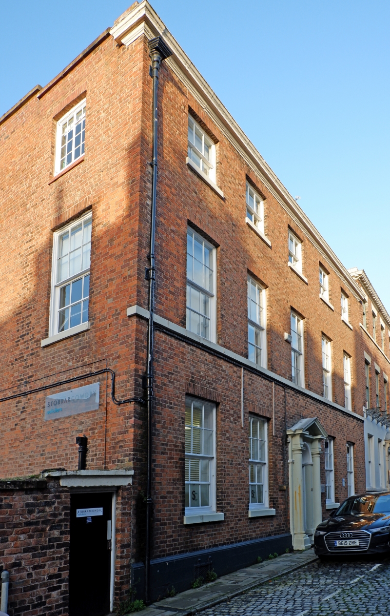
House, then Chester Rural District Council Offices, now a
municipal office. Late C18, altered internally and extended to
rear. Flemish bond brown brick; the hipped grey roof, behind
parapets, has 2 ridges parallel with the street.
EXTERIOR: 3 storeys, 5 windows. Painted stone plinth; 2
renewed steps to door of 1;2;2;1 panels, the lower 3 fielded
and the upper 3 now glazed, and a 4-pane radial-bar fanlight
in a Roman Doric stone doorcase with 3-quarter columns, frieze
and pediment; 2 recessed 12-pane sashes to each side have
lower leaves altered; painted stone sills; the windows to all
storeys have gauged-brick flat arches. The second storey has a
sillband and 5 recessed 12-pane sashes; the third storey has a
sillband and 5 recessed 6-pane sashes; a lead rainwater pipe;
full cornice of painted stone.
The C18 rear is largely hidden by the C20 extension, but the
large stair-sash with radial-bar fan in round-arched head is
visible.
INTERIOR: a stone-flagged brick, barrel-vaulted, cellar is
probably all C18. The hall has skirting, replaced door in
round archway with fluted corner pilasters, architraves and
fanlight with glazing bars removed; plain frieze and modillion
cornice; the stair hall has round archway to rear with fluted
pilasters; the east and west front rooms have cornices; the
west rear room has a cornice, the east room a recessed 16-pane
sash largely concealed from without and a cornice; the former
kitchen in the rear wing has basket-arched recesses for range
and cupboards, now empty; the former back kitchen has a
quarry-tile floor. The open-well stair has open string with
shaped brackets, covered steps, square newels with
urn-finials, renewed stick balusters and swept oak rail with
wreath. The second storey landing has skirting and modillion
cornice, the front passage has skirting and cornice; the west
rooms were joined, with a new dado, to form the Rural District
Council Chamber; the rear passage has a cornice. The stair to
the third storey is like that below, but with probably
original reeded balusters; most doors are replaced but
architraves are retained. An internal boxed gutter runs from
the back to the front of the building.
Listing NGR: SJ4045466097
External links are from the relevant listing authority and, where applicable, Wikidata. Wikidata IDs may be related buildings as well as this specific building. If you want to add or update a link, you will need to do so by editing the Wikidata entry.


Other nearby listed buildings
