Latitude: 52.2441 / 52°14'38"N
Longitude: 0.7165 / 0°42'59"E
OS Eastings: 585558
OS Northings: 264130
OS Grid: TL855641
Mapcode National: GBR QF0.7Z3
Mapcode Global: VHKD4.CVNK
Plus Code: 9F426PV8+JJ
Entry Name: 34, Angel Hill
Listing Date: 12 July 1972
Grade: II
Source: Historic England
Source ID: 1376998
English Heritage Legacy ID: 466646
ID on this website: 101376998
Location: Bury St Edmunds, West Suffolk, IP33
County: Suffolk
District: West Suffolk
Civil Parish: Bury St Edmunds
Built-Up Area: Bury St Edmunds
Traditional County: Suffolk
Lieutenancy Area (Ceremonial County): Suffolk
Church of England Parish: Bury St Edmunds St Mary
Church of England Diocese: St.Edmundsbury and Ipswich
Tagged with: Building
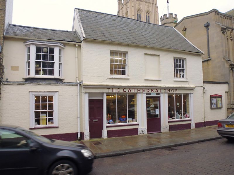
BURY ST EDMUNDS
TL8564SE ANGEL HILL
639-1/8/184 (East side)
12/07/72 No.34
GV II
Shop and offices, formerly shop and house. C16 core, early C19
front. Timber-framed, faced on the front with painted brick;
slate roof.
EXTERIOR: 2 storeys; a one-bay addition on the north and a
small rear extension. Basic 2-cell plan. 3 window range, 2
16-pane sash windows in deep reveals and one central blocked
window. Late C20 shop front in traditional style with a plain
fascia, vertical glazing-bars to lights and a central entry. A
door on the left leads to the storey above. The small adjacent
section on the north is timber-framed and rendered on the
upper storey and faced on the ground storey with a projecting
layer of painted brick; shallow-pitched slate roof. It has a
canted bay on the upper storey with sash windows in heavy
moulded cased frames, 12-pane to the central window,
diminished side-lights.
INTERIOR: the main range has an original stud partition
dividing the upper storey into 2 rooms; on the ground storey a
chamfered main ceiling-beam with curved stepped stops is
mainly boxed in. The extended rear wall has a section of
random stone blocks.
Listing NGR: TL8555864130
External links are from the relevant listing authority and, where applicable, Wikidata. Wikidata IDs may be related buildings as well as this specific building. If you want to add or update a link, you will need to do so by editing the Wikidata entry.


Other nearby listed buildings