Approximate Location Map
Large Map »
Latitude: 52.2462 / 52°14'46"N
Longitude: 0.7144 / 0°42'51"E
OS Eastings: 585406
OS Northings: 264359
OS Grid: TL854643
Mapcode National: GBR QF0.1G0
Mapcode Global: VHKD4.BSJY
Plus Code: 9F426PW7+FQ
Entry Name: Kings Arms Public House
Listing Date: 30 October 1997
Grade: II
Source: Historic England
Source ID: 1377010
English Heritage Legacy ID: 466658
ID on this website: 101377010
Location: Bury St Edmunds, West Suffolk, IP33
County: Suffolk
District: West Suffolk
Civil Parish: Bury St Edmunds
Built-Up Area: Bury St Edmunds
Traditional County: Suffolk
Lieutenancy Area (Ceremonial County): Suffolk
Church of England Parish: Bury St Edmunds St John the Evangelist
Church of England Diocese: St.Edmundsbury and Ipswich
Tagged with: Pub
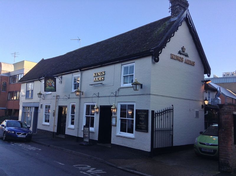
BURY ST EDMUNDS
TL8564SW BRENTGOVEL STREET
639-1/7/199 (South side)
No.23
King's Arms Public House
II
Public house. C17 with C19 alterations; older core to part.
Timber-framed, encased in C19 brick, now painted. Old
plaintiles.
EXTERIOR: 2 storeys and cellars; T-shaped form with a long
rear range. 3 sash windows to the upper storey, all with a
single vertical bar to lights, in heavy cased frames with
shallow reveals, flat cement arches and stone sills. 3 similar
but larger windows to the ground storey and one narrower sash
without glazing-bars. 2 doorways with moulded surrounds have
half-glazed double doors. Pierced and fluted barge-boards to
the west gable. The rear range is rendered, with a
shallow-pitched roof.
INTERIOR: the cellars extend below the whole of the rear
range. Main beams and wallplates are exposed on the upper
storey of the front range. The rear range is in 2 sections
with the half adjoining the front originally lower. The lower
wallplate is visible along the east wall with a barefaced
dovetail halving for a former tie-beam.
Listing NGR: TL8540664359
External links are from the relevant listing authority and, where applicable, Wikidata. Wikidata IDs may be related buildings as well as this specific building. If you want to add or update a link, you will need to do so by editing the Wikidata entry.


Other nearby listed buildings
