Approximate Location Map
Large Map »
Latitude: 53.6468 / 53°38'48"N
Longitude: -2.9852 / 2°59'6"W
OS Eastings: 334973
OS Northings: 417155
OS Grid: SD349171
Mapcode National: GBR 7VL8.JF
Mapcode Global: WH862.3LRM
Plus Code: 9C5VJ2W7+PW
Entry Name: Church of St Luke
Listing Date: 29 July 1999
Grade: II
Source: Historic England
Source ID: 1379772
English Heritage Legacy ID: 479180
ID on this website: 101379772
Location: St Luke's Church, Sefton, Merseyside, PR9
County: Sefton
Electoral Ward/Division: Norwood
Parish: Non Civil Parish
Built-Up Area: Southport
Traditional County: Lancashire
Lieutenancy Area (Ceremonial County): Merseyside
Church of England Parish: Southport St Luke
Church of England Diocese: Liverpool
Tagged with: Church building
SOUTHPORT
SD31NW ST LUKE'S ROAD
664-1/1/205 (East side)
Church of St Luke
II
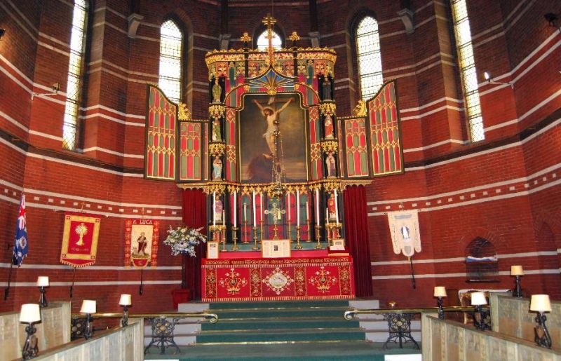
Church. 1878-80, by Mellor and Sutton. Red brick with some
blue brick dressings, slate roofs.
STYLE: Severe Early English.
PLAN: tall nave with lean-to baptistery at west end clasped by
gabled porches, low lean-to aisles, chancel with transepts and
round apse.
EXTERIOR: 5-bay nave with pilaster strips and 2 small lancet
clerestory windows in each bay; aisles with simple buttresses
and 3 small lancets in each bay. Bellcote at junction with
chancel. At the west end the buttressed 2-window baptistery
reaches up to half the height of the west wall, and above this
a pair of pilaster strips frame 3 blind lancets, a blind
oculus and a small triple lancet in the gable above.
Large porches, at right-angles to the sides of baptistery,
with large 2-centred arched doorways in the gables and small
triple lancets in the west sides.
INTERIOR: not inspected but known to have exposed brick walls,
columns of granite with big shaft-rings and untraditional
capitals.
Listing NGR: SD3497317155
External links are from the relevant listing authority and, where applicable, Wikidata. Wikidata IDs may be related buildings as well as this specific building. If you want to add or update a link, you will need to do so by editing the Wikidata entry.


Other nearby listed buildings
