Latitude: 50.8217 / 50°49'18"N
Longitude: -0.1417 / 0°8'30"W
OS Eastings: 530992
OS Northings: 104111
OS Grid: TQ309041
Mapcode National: GBR JP4.F02
Mapcode Global: FRA B6LX.NM8
Plus Code: 9C2XRVC5+M8
Entry Name: 59, Ship Street
Listing Date: 20 August 1971
Grade: II
Source: Historic England
Source ID: 1380923
English Heritage Legacy ID: 481247
ID on this website: 101380923
Location: Brighton and Hove, West Sussex, BN1
County: The City of Brighton and Hove
Electoral Ward/Division: Regency
Parish: Non Civil Parish
Built-Up Area: Brighton and Hove
Traditional County: Sussex
Lieutenancy Area (Ceremonial County): East Sussex
Church of England Parish: Brighton St Paul
Church of England Diocese: Chichester
Tagged with: Building
BRIGHTON
TQ3004SE SHIP STREET
577-1/39/839 (East side)
20/08/71 No.59
GV II
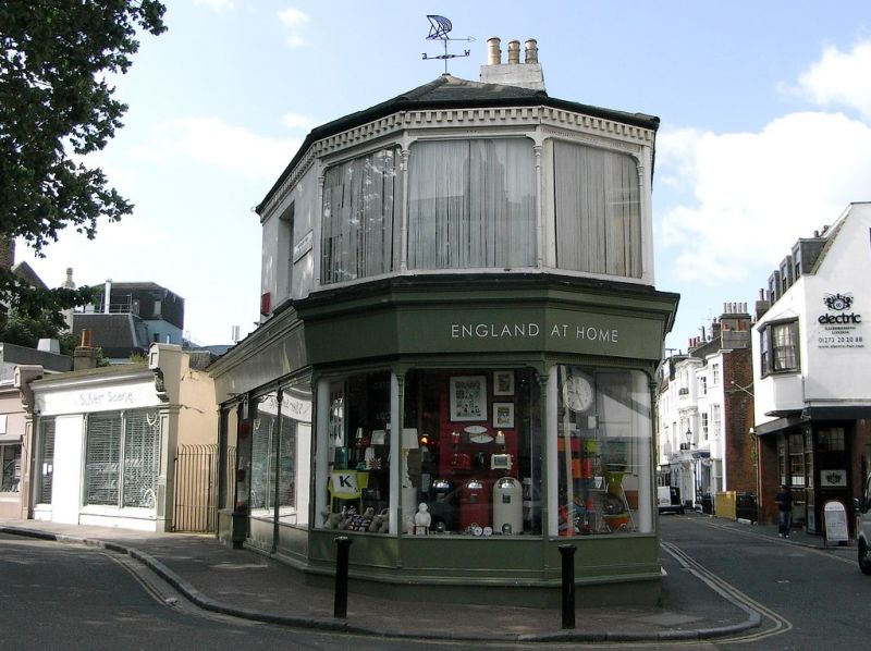
Terraced house, early C19, with alterations and additions as
shops, late C19 or early C20. The original building of yellow
brick set in header bond, stucco, roof obscured by parapet.
EXTERIOR: 3 storeys over basement, 3-window range,
double-fronted. Central, elliptical-arched entrance with
overlight, doorcase consisting of pilasters, panelled
archivolt and keystone, and flanked by pilasters supporting
entablature and open pediment. C19 shop front to either side
retaining original glazing bars with quadrant corners, grilles
to basement and entrances with quadrant-cornered doors and
overlights; flanked at either end by pilasters fluted in the
lower part and panelled above; deep fascia brackets fluted on
their faces with antefixa above to right; all upper windows
cambered-arched with mid-C19 sashes; stucco band to
entablature; cornice and parapet; side-stacks.
INTERIOR: staircase with curtail step, wreathed rail, fluted
newel, stick balusters and open string.
No.59 continues to the corner with Prince Albert Street as a
2-storey stuccoed block, with the shop front carried round to
10 bays, with original details as for No.59 proper; fascia
with one fluted fascia bracket in Ship Street; first floor has
3 shop windows as for ground floor on corner; otherwise
flat-arched windows; dentil cornice; hipped roof of slate.
Listing NGR: TQ3099204111
External links are from the relevant listing authority and, where applicable, Wikidata. Wikidata IDs may be related buildings as well as this specific building. If you want to add or update a link, you will need to do so by editing the Wikidata entry.


Other nearby listed buildings