Approximate Location Map
Large Map »
Latitude: 51.2097 / 51°12'34"N
Longitude: -2.646 / 2°38'45"W
OS Eastings: 354971
OS Northings: 145805
OS Grid: ST549458
Mapcode National: GBR MN.43GL
Mapcode Global: VH89S.3V1J
Plus Code: 9C3V6953+VJ
Entry Name: 14, Sadler Street
Listing Date: 13 September 1972
Grade: II
Source: Historic England
Source ID: 1383088
English Heritage Legacy ID: 483506
ID on this website: 101383088
Location: Wells, Somerset, BA5
County: Somerset
District: Mendip
Civil Parish: Wells
Built-Up Area: Wells
Traditional County: Somerset
Lieutenancy Area (Ceremonial County): Somerset
Tagged with: Building
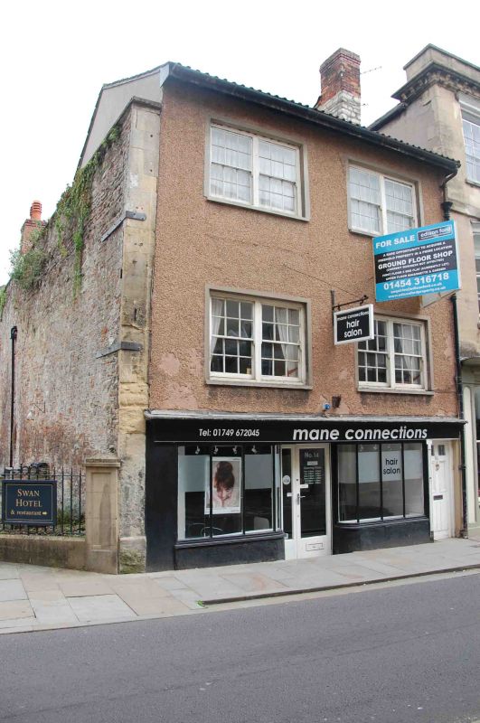
WELLS
ST5445 SADLER STREET
662-1/7/225 (East side)
13/09/72 No.14
GV II
House, now shop with flat over. Mid to late C18 facade to
earlier property. Roughcast, double Roman clay tiled roof with
plain gable to north and abutment to south. Parallel-range
double-depth plan, the rear (E) side facing Cathedral Green.
EXTERIOR: 3 storeys, 2 bays; late C19 shop front under shallow
full-width fascia, with 3-light display window plus curved
quadrants on either side of the central recessed doorway, all
to narrow glazing bars; on right a 6-panel door for access to
upper floors. Upper floors each have paired 12-pane sashes in
smooth rendered architraves. On north flank is an additional
retaining wall in random stone rubble, to eaves level, with
flat coping, dating from the clearance of the adjoining site
to form the Swan Garden c1869.
Rear elevation rendered, with matching roof, and brick chimney
stack, 2 storeys and attic, single bay. Ground floor has a
12-pane sash in plain surround with exposed sash boxes and a
part-glazed door to the left. At first floor a 16-pane sash
window, and high gabled face dormer above, with tiled cheeks.
INTERIOR: not inspected.
HISTORICAL NOTE: this property was first established c1370,
when the E side of Sadler Street was developed; the building
originally straddled a N/S wall to the Cathedral Precinct.
(Town and Country Planning Working Papers: Scrase AJ: Wells: A
Study of Town Origins: Bristol: 1982-: 59).
Listing NGR: ST5497145807
External links are from the relevant listing authority and, where applicable, Wikidata. Wikidata IDs may be related buildings as well as this specific building. If you want to add or update a link, you will need to do so by editing the Wikidata entry.


Other nearby listed buildings
