Latitude: 51.2092 / 51°12'33"N
Longitude: -2.648 / 2°38'52"W
OS Eastings: 354832
OS Northings: 145753
OS Grid: ST548457
Mapcode National: GBR MN.42Y0
Mapcode Global: VH89S.1VZX
Plus Code: 9C3V6952+MR
Entry Name: 18, Union Street
Listing Date: 13 November 1979
Last Amended: 31 May 2000
Grade: II
Source: Historic England
Source ID: 1383193
English Heritage Legacy ID: 483611
ID on this website: 101383193
Location: Wells, Somerset, BA5
County: Somerset
District: Mendip
Civil Parish: Wells
Built-Up Area: Wells
Traditional County: Somerset
Lieutenancy Area (Ceremonial County): Somerset
Tagged with: Building
WELLS
ST5445 UNION STREET
662-1/7/328 (East side)
13/11/79 No.18
(Formerly Listed as:
UNION STREET
Nos.18 AND 18A)
GV II
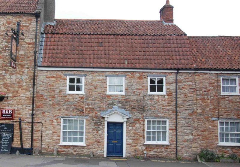
House in row. Early C19, with some mid/late C20 alteration.
Random rubble stonework, clay pantiled mansard roof with
abutment to north and plain gable to south, brick chimney
stacks. Double-depth plan.
EXTERIOR: 2 storeys, 3 bays. Ground floor has 16-pane sash
windows, and first floor 4-pane windows. Central C20 door set
in timber surround with open pediment hood on brackets.
INTERIOR: not inspected.
Listing NGR: ST5483245753
External links are from the relevant listing authority and, where applicable, Wikidata. Wikidata IDs may be related buildings as well as this specific building. If you want to add or update a link, you will need to do so by editing the Wikidata entry.


Other nearby listed buildings