Approximate Location Map
Large Map »
Latitude: 52.4045 / 52°24'16"N
Longitude: -2.5735 / 2°34'24"W
OS Eastings: 361081
OS Northings: 278653
OS Grid: SO610786
Mapcode National: GBR BR.PR4N
Mapcode Global: VH840.BTVL
Plus Code: 9C4VCC3G+QJ
Entry Name: Church of St Mary
Listing Date: 23 November 1992
Grade: II
Source: Historic England
Source ID: 1383665
English Heritage Legacy ID: 484097
ID on this website: 101383665
Location: St Mary's Church, Cleeton St Mary, Shropshire, DY14
County: Shropshire
Civil Parish: Bitterley
Traditional County: Shropshire
Lieutenancy Area (Ceremonial County): Shropshire
Church of England Parish: Cleeton St Mary
Church of England Diocese: Hereford
Tagged with: Church building
BITTERLEY
SO67NW CLEETON ST MARY
482-1/7/77 Church of St Mary
23/11/92
II
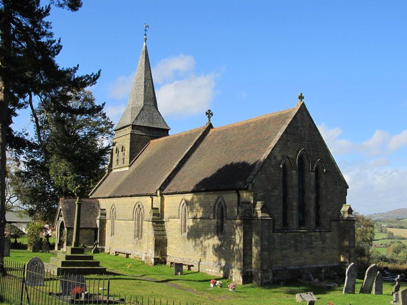
Church. 1878. By T Nicholson of Hereford for Rev George
Pardoe. Coursed squared stone with stone dressings and
plain-tile and shingle roofs, with stone-coped gables and
finials. Early English style.
PLAN: chancel, nave, west tower within nave, south porch, and
north organ chamber and vestry.
EXTERIOR: plinth, buttresses with offsets and continuous
string course running over most windows as a hoodmould.
Chancel: triple lancets to east, 2 lancets to south and
lean-to vestry to north with small paired lancets and
north-east door. Nave: single and paired lancets and south
porch with timber-framed entrance arch decorated with
open-work trefoils and quatrefoil and ornamental bargeboards.
Single lancet to west of nave and single-stage tower above
with twin lancet bell-chamber openings, quatrefoil frieze and
shingle broach spire.
INTERIOR: roofs with curved braces to collars, the west bay
boarded. Chancel with aumbry, piscina and sedilia, choir
stalls and open-work screen. Nave has pulpit, font and pews.
Some stained glass. Narthex at west end formed of one large
and 2 small open arches, the large arch repeated to north and
south behind the arcade within the space and all supporting
the tower.
Listing NGR: SO6108178653
External links are from the relevant listing authority and, where applicable, Wikidata. Wikidata IDs may be related buildings as well as this specific building. If you want to add or update a link, you will need to do so by editing the Wikidata entry.


Other nearby listed buildings
