Approximate Location Map
Large Map »
Latitude: 54.3039 / 54°18'14"N
Longitude: -2.5212 / 2°31'16"W
OS Eastings: 366184
OS Northings: 489935
OS Grid: SD661899
Mapcode National: GBR BLTN.ZY
Mapcode Global: WH94B.72PW
Plus Code: 9C6V8F3H+HG
Entry Name: Rash House
Listing Date: 14 June 1984
Last Amended: 18 October 1999
Grade: II
Source: Historic England
Source ID: 1383929
English Heritage Legacy ID: 484361
ID on this website: 101383929
Location: Westmorland and Furness, Cumbria, LA10
County: Cumbria
District: South Lakeland
Civil Parish: Dent
Traditional County: Yorkshire
Lieutenancy Area (Ceremonial County): Cumbria
Church of England Parish: Dent with Cowgill
Church of England Diocese: Carlisle
Tagged with: House
DENT
SD68NE DENTDALE
162-1/10/131 (North side)
14/06/84 Rash House
(Formerly Listed as:
DENTDALE
Rash, barn adjoining to east, barn
to west and barn to south-west)
GV II
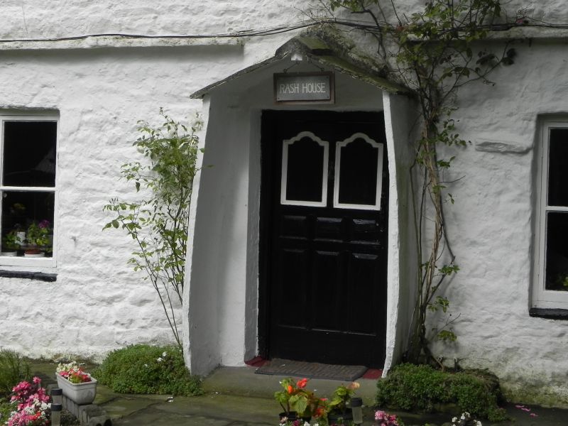
Farmhouse, now house. Probably mid C18; altered. White-washed
roughly-coursed rubble with quoins, slate roof. Double-depth
plan, plus a short set-back service wing to the right (now
ruinous).
EXTERIOR: 2 storeys and attic, 2 windows, almost symmetrical;
with a continuous stone slate drip-course over the ground
floor. The ground floor has a square-headed doorway offset
slightly right of centre, with C18 fielded panel door, the top
panels shouldered, protected by a small gabled porch made with
monolith stone slab sides (now bowed outwards) and stone slate
roof, flanked by square 2-light casements; the 1st floor has
2-light casements with glazing bars in matching openings
vertically aligned with those below. Gable chimneys. Former
2-storey service wing, now partly collapsed and lacking upper
floor, has stone shelving of former dairy.
INTERIOR: housepart to right has doors with fielded panelling,
parlour to left has built-in cupboard with matching double
doors; doglegged staircase with closed string, rectangular
newels, short turned balusters to the upper flight; coupled
chamber doorways with fielded panel doors; roof of 2 large
pegged collar trusses with raked struts, the principals
apparently re-used cruck blades. Forms group with barn to
south (qv).
Listing NGR: SD6618489935
External links are from the relevant listing authority and, where applicable, Wikidata. Wikidata IDs may be related buildings as well as this specific building. If you want to add or update a link, you will need to do so by editing the Wikidata entry.


Other nearby listed buildings
