Approximate Location Map
Large Map »
Latitude: 53.5546 / 53°33'16"N
Longitude: -2.6288 / 2°37'43"W
OS Eastings: 358438
OS Northings: 406628
OS Grid: SD584066
Mapcode National: GBR BW2B.NH
Mapcode Global: WH97R.LXDB
Plus Code: 9C5VH93C+VF
Entry Name: 2-20, Swinley Road
Listing Date: 25 September 1995
Grade: II
Source: Historic England
Source ID: 1384533
English Heritage Legacy ID: 484968
ID on this website: 101384533
Location: Swinley, Wigan, Greater Manchester, WN1
County: Wigan
Electoral Ward/Division: Wigan Central
Parish: Non Civil Parish
Built-Up Area: Wigan
Traditional County: Lancashire
Lieutenancy Area (Ceremonial County): Greater Manchester
Church of England Parish: Wigan St Michael and All Angels
Church of England Diocese: Liverpool
Tagged with: Building
WIGAN
SD50NE SWINLEY ROAD
24-1/2/84 (North side)
25/09/95 Nos.2-20 (Even)
GV II
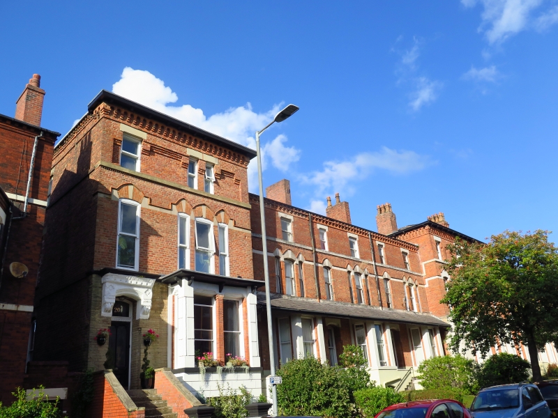
Terrace of 10 town houses, now subdivided. 1875, by J Ford
Mackenzie of Wigan, for the Wigan Land and Building Company;
altered. Red brick, in header bond at ground floor and English
garden wall bond above, with some facing of sandstone rubble
and scored stucco; slate roofs on 2 levels, hipped over the
centre and ends. Double-depth plan, each house single-fronted,
with back extensions (coupled at the centre and ends).
Eclectic style, with Gothic and Italianate features.
EXTERIOR: 3 storeys over basements, 2:3:3:2:2:3:3:2 windows;
symmetrical composition, Nos 8 and 10 in the centre, and Nos 2
and 20 at the ends breaking forwards and taller than the
intermediate ranges. All have scored stucco basements with
segmental-headed windows (glazing altered); the centre and
ends have sandstone rubble facing to the ground floor, Lombard
friezes to bracketed eaves; the intermediate ranges have
continuous slated pentice roofing over the ground floor, and
brick corbel tables to the eaves broken by a sawtooth course;
the whole range has an impost band at 1st floor and a sillband
on dogtoothing at 2nd floor. High flights of steps,
quarter-turned except at the ends, lead to tall
segmental-headed doorways, those in the centre and ends with
heavy corbelled cornices, and all with doors which have
colonnetted 2-light glazing, and overlights. At ground floor
all have bay windows, those in the centre and ends rectangular
with pilasters and prominent cornices, and the others canted.
At 1st floor each has a tall tripartite widow and a
single-light window, with segmental-headed lights and
polychrome extrados and linked archbands of moulded brick; at
2nd floor the centre and ends have one-and 2-light windows
with enriched sunk panels between, the others have 2 one-light
windows. Most windows sashed without glazing bars. Chimneys on
front slope.
Rear: 2-storey back extensions, those to the centre and ends
with monopitched roofs; windows with altered glazing.
Good example of later Victorian town housing. Forms group with
Nos 5-15 opposite (qv) and with Church of St Michael to west
(qv).
INTERIOR not inspected. Included for group value.
Listing NGR: SD5843806628
External links are from the relevant listing authority and, where applicable, Wikidata. Wikidata IDs may be related buildings as well as this specific building. If you want to add or update a link, you will need to do so by editing the Wikidata entry.


Other nearby listed buildings
