Latitude: 50.9034 / 50°54'12"N
Longitude: -3.4835 / 3°29'0"W
OS Eastings: 295780
OS Northings: 112597
OS Grid: SS957125
Mapcode National: GBR LJ.RF8T
Mapcode Global: FRA 36LQ.8PC
Plus Code: 9C2RWG38+9H
Entry Name: Lowman Bridge
Listing Date: 10 April 2000
Grade: II
Source: Historic England
Source ID: 1384853
English Heritage Legacy ID: 485312
ID on this website: 101384853
Location: Tiverton, Mid Devon, EX16
County: Devon
District: Mid Devon
Civil Parish: Tiverton
Built-Up Area: Tiverton
Traditional County: Devon
Lieutenancy Area (Ceremonial County): Devon
Church of England Parish: Tiverton St George
Church of England Diocese: Exeter
Tagged with: Bridge
TIVERTON
SS9512 LOWMAN GREEN, Tiverton
848-1/6/223 (West side)
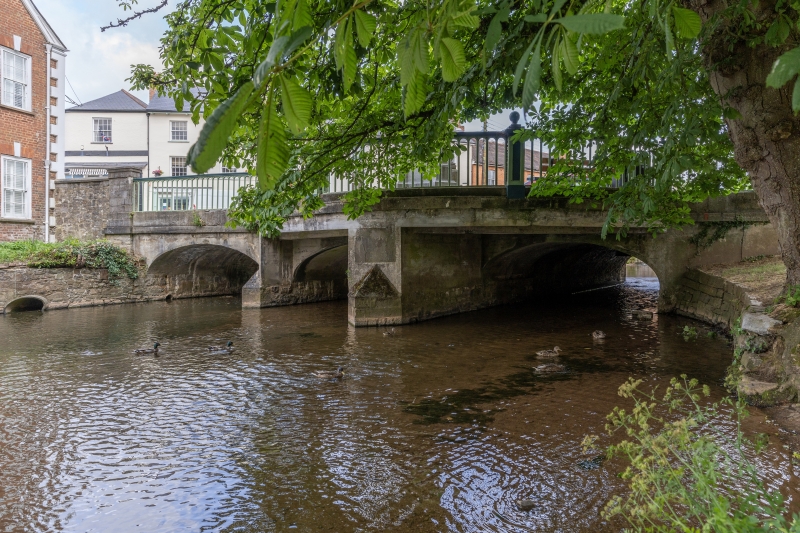
Lowman Bridge
GV II
Bridge over the River Lowman, at the eastern end of Gold
Street. 1851, the south side widened in 1911. Squared stone
rubble with well-cut voussoirs to the arches; cast-iron
balustrades. The bridge consists of 3 elliptical arches, the
south side having been built out in a semicircle to carry a
statue of King Edward VII. Piers have cutwaters on both sides.
Balustrades have a series of narrow, round-arched open panels
with a handrail on top; at intervals are square iron piers
with panelled sides and ball finials. At each end of each
balustrade is an oblong section stone pier with a low
pyramidical cap.
On the eastern pier of the south side is a stone tablet
inscribed THIS BRIDGE WAS WIDENED DURING THE MAYORALTY OF
ALDERMAN west THORNE 2nd NOV.er 1911. Above the eastern
cutwater on the south side is another tablet (badly worn)
which seems to read LOWMAN BRIDGE WIDENED 1911.
The foundation stone of the bridge was laid in October 1851 by
John Heathcoat, MP for Tiverton.
The previous bridge, also of stone but with 2 arches, was
`repaired and nearly rebuilt' in 1772.
Listing NGR: SS9578012597
External links are from the relevant listing authority and, where applicable, Wikidata. Wikidata IDs may be related buildings as well as this specific building. If you want to add or update a link, you will need to do so by editing the Wikidata entry.


Other nearby listed buildings