Approximate Location Map
Large Map »
Latitude: 50.9003 / 50°54'0"N
Longitude: -3.4611 / 3°27'40"W
OS Eastings: 297348
OS Northings: 112216
OS Grid: SS973122
Mapcode National: GBR LK.RLYN
Mapcode Global: FRA 36MQ.KDW
Plus Code: 9C2RWG2Q+4G
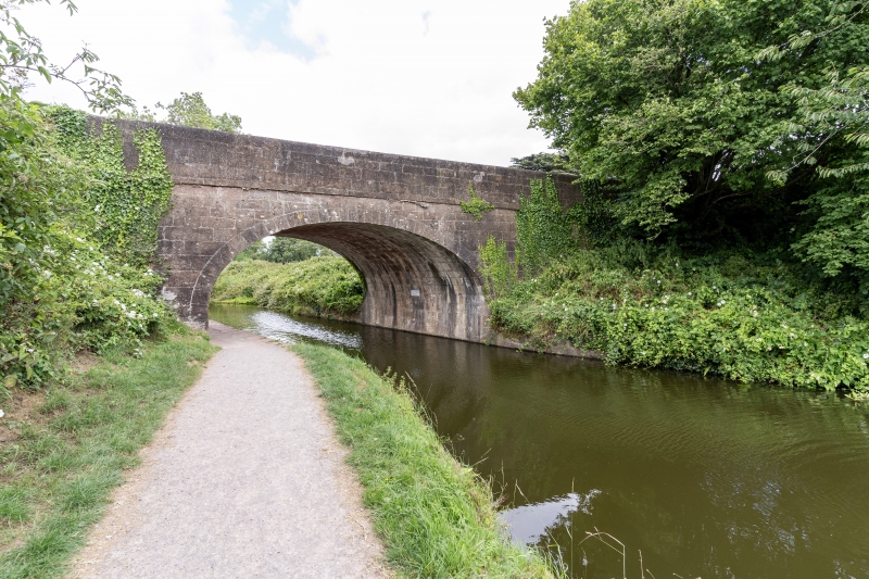
Entry Name: Tidcombe Bridge
Listing Date: 12 February 1952
Grade: II
Source: Historic England
Source ID: 1384969
English Heritage Legacy ID: 485428
ID on this website: 101384969
Location: Mid Devon, EX16
County: Devon
District: Mid Devon
Civil Parish: Tiverton
Built-Up Area: Tiverton
Traditional County: Devon
Lieutenancy Area (Ceremonial County): Devon
Church of England Parish: Tiverton St Andrew
Church of England Diocese: Exeter
Tagged with: Bridge
TIVERTON
SS91SE TIDCOMBE LANE, Tidcombe
848-1/7/98 Tidcombe Bridge
12/02/52
II
Road bridge over canal. Probably 1810-14 contemporary with the
construction of the Great Western Canal. Volcanic agglomerate
ashlar with parapet string and hogs-back parapet. Single span
with elliptical arch, the bridge as 2 opposing segmental
arches on plan and with the walls slightly battered.
Listing NGR: SS9734812216
External links are from the relevant listing authority and, where applicable, Wikidata. Wikidata IDs may be related buildings as well as this specific building. If you want to add or update a link, you will need to do so by editing the Wikidata entry.


Other nearby listed buildings
