Approximate Location Map
Large Map »
Latitude: 51.08 / 51°4'48"N
Longitude: -4.0619 / 4°3'42"W
OS Eastings: 255663
OS Northings: 133212
OS Grid: SS556332
Mapcode National: GBR KQ.DBSD
Mapcode Global: FRA 26C8.KC6
Plus Code: 9C3Q3WJQ+26
Entry Name: Garage at East End of the Anchor Public House (The Anchor Public House Not Included)
Listing Date: 31 August 1988
Last Amended: 29 September 1999
Grade: II
Source: Historic England
Source ID: 1385189
English Heritage Legacy ID: 485651
ID on this website: 101385189
Location: Barnstaple, North Devon, EX31
County: Devon
District: North Devon
Civil Parish: Barnstaple
Built-Up Area: Barnstaple
Traditional County: Devon
Lieutenancy Area (Ceremonial County): Devon
Church of England Parish: Barnstaple St Peter and St Mary Magdalene
Church of England Diocese: Exeter
Tagged with: Garage
BARNSTAPLE
SS5533SE HOLLAND STREET
684-1/7/178 (South side)
31/08/88 Garage at east end of The Anchor
Public House (The Anchor PH not
included)
(Formerly Listed as:
HOLLAND STREET
(South side)
The Pit Stop (formerly the Golden
Anchor):garage at east end only.)
II
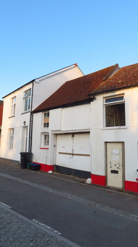
Cottage converted to garage, now forming eastern end of a
public house (not included). C17. Solid, rendered front wall,
probably of stone or cob, side walls of cob on a high stone
rubble plinth; rear wall of stone rubble, the lower part
mostly rebuilt in concrete block. Pantiled roof. 1-room plan,
approx 5.3m wide and 5.2m deep.
2 storeys. Front has wide vehicle entrance to right and small
segmental-headed window to left. Latter contains a chamfered,
rectangular wood frame of C17 which must originally have had a
central mullion; it now has a 6-paned fixed sash. No
upper-storey windows.
INTERIOR: chamfered upper floor beam with scroll-stops,
clearly designed for a room of this width; fairly rough, plain
joists, evidently made to fit this beam. Old floor boards
above, probably re-used, to judge from the position of the
redundant pegs fitted to them. No staircase, and no access at
present to upper storey.
This building is a rare survival of a small C17 cottage, and
though altered retains enough of its original shape and
character to be of significance. It is shown as a separate
dwelling in John Wood's map of 1843; there are no grounds for
thinking it was originally part of a larger house.
The public house itself (not included) is also an early
structure much altered in C19. The walls are very thick in
places and there are some old roof trusses, heavily plastered.
The ground storey bar to left of the main entrance has one end
of a chamfered upper floor beam and during building work in
1985 a large fireplace was partly exposed in the rear wall.
The builders reported seeing a joist dated 1648 or 1668,
apparently in its original position, in the eastern room next
to the garage.
(Wood J: Map of Barnstaple: 1843-).
Listing NGR: SS5566333212
External links are from the relevant listing authority and, where applicable, Wikidata. Wikidata IDs may be related buildings as well as this specific building. If you want to add or update a link, you will need to do so by editing the Wikidata entry.


Other nearby listed buildings
