Approximate Location Map
Large Map »
Latitude: 51.4765 / 51°28'35"N
Longitude: -0.0647 / 0°3'52"W
OS Eastings: 534497
OS Northings: 177062
OS Grid: TQ344770
Mapcode National: GBR YS.LW
Mapcode Global: VHGR6.T4NX
Plus Code: 9C3XFWGP+J4
Entry Name: 127-151, Friary Road
Listing Date: 27 September 1972
Last Amended: 17 September 1998
Grade: II
Source: Historic England
Source ID: 1385537
English Heritage Legacy ID: 470940
ID on this website: 101385537
Location: Peckham, Southwark, London, SE15
County: London
District: Southwark
Electoral Ward/Division: Peckham
Parish: Non Civil Parish
Built-Up Area: Southwark
Traditional County: Surrey
Lieutenancy Area (Ceremonial County): Greater London
Church of England Parish: Peckham St John with Andrew
Church of England Diocese: Southwark
Tagged with: Building
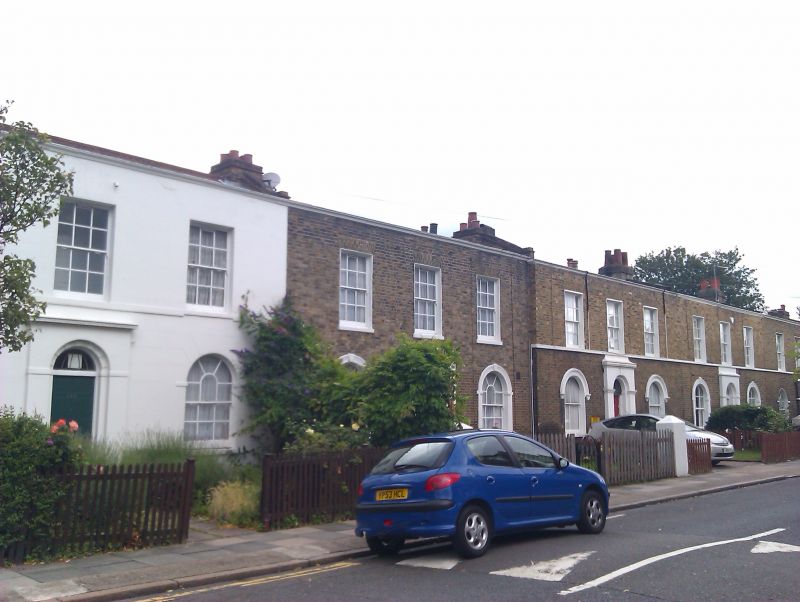
SOUTHWARK
TQ3477SW FRIARY ROAD
636-1/39/353 (East side)
27/09/72 Nos.127-151 (Odd)
(Formerly Listed as:
FRIARY ROAD
(East side)
Nos.121, 123 AND 127-151 (Odd))
GV II
Terrace of 13 houses. Early C19, some apparently rebuilt.
Yellow brick (No.131 stuccoed) with low-pitched roof behind
coped parapet.
2 storeys, 3 bays each. Round-arched doors recessed in
slightly projecting ground-floor centre piece with stucco
crown and band at spring, Nos 133-137 with entire doorpiece
stuccoed; Nos 127-131, 135, 137 & 151 with decorative
fanlights. Ground-floor round-arched sash windows with glazing
bars and stucco impost blocks, Nos 133-137 with stucco
architraves. Gauged, flat brick arches to 1st-floor sash
windows, mostly with glazing bars.
INTERIOR: not inspected.
Nos 121, 123 & 127-151 (odd) (qv) form a group.
Listing NGR: TQ3449777062
External links are from the relevant listing authority and, where applicable, Wikidata. Wikidata IDs may be related buildings as well as this specific building. If you want to add or update a link, you will need to do so by editing the Wikidata entry.


Other nearby listed buildings
