Approximate Location Map
Large Map »
Latitude: 51.4706 / 51°28'14"N
Longitude: -0.0739 / 0°4'25"W
OS Eastings: 533878
OS Northings: 176386
OS Grid: TQ338763
Mapcode National: GBR WW.K0
Mapcode Global: VHGR6.N9TG
Plus Code: 9C3XFWCG+6F
Entry Name: Lyndhurst Terrace
Listing Date: 17 September 1998
Grade: II
Source: Historic England
Source ID: 1385678
English Heritage Legacy ID: 471082
ID on this website: 101385678
Location: Peckham, Southwark, London, SE15
County: London
District: Southwark
Electoral Ward/Division: The Lane
Parish: Non Civil Parish
Built-Up Area: Southwark
Traditional County: Surrey
Lieutenancy Area (Ceremonial County): Greater London
Church of England Parish: Peckham All Saints
Church of England Diocese: Southwark
Tagged with: Building
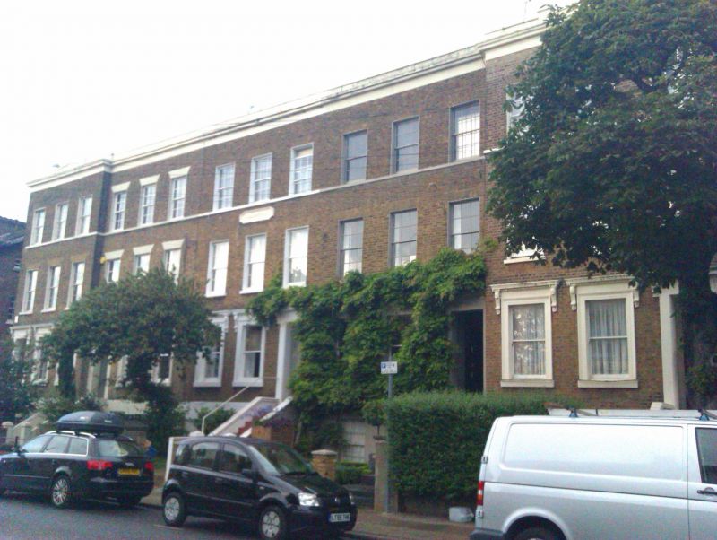
SOUTHWARK
TQ3376 LYNDHURST WAY
636-1/11/501 (East side)
Nos.21-29 (Odd)
Lyndhurst Terrace
GV II
5 terraced houses. Mid C19. Brick in Flemish bond with stucco
dressings and stucco facing to basement. Roof parapeted.
3 storeys over basement. 3 windows each, the end units
projecting forward to form a flattened U-shaped plan. All
entrances are reached up a flight of stairs and are set within
porch having flush stone surround. Ground-floor windows have
moulded architraves, all ground-floor openings topped by a
cornice projecting on a pair of console brackets. First- and
2nd-floor windows with lintels of gauged brick. Sill band to
2nd-floor windows. Entablature with projecting cornice and
parapet in stucco continuous across terrace.
In the centre of the terrace, on front wall of No.25, between
the 1st and 2nd floors is rectangular plaque bearing the name
of the group, "Lyndhurst Terrace".
INTERIOR: not inspected.
Nos 21-41 (odd) Lyndhurst Way (qv) form a group.
Listing NGR: TQ3387876386
External links are from the relevant listing authority and, where applicable, Wikidata. Wikidata IDs may be related buildings as well as this specific building. If you want to add or update a link, you will need to do so by editing the Wikidata entry.


Other nearby listed buildings
