Approximate Location Map
Large Map »
Latitude: 51.4778 / 51°28'40"N
Longitude: -0.0831 / 0°4'59"W
OS Eastings: 533218
OS Northings: 177169
OS Grid: TQ332771
Mapcode National: GBR TS.HF
Mapcode Global: VHGR6.H3YY
Plus Code: 9C3XFWH8+4Q
Entry Name: 190, 192 and 194, Southampton Way
Listing Date: 17 September 1998
Grade: II
Source: Historic England
Source ID: 1385911
English Heritage Legacy ID: 471330
ID on this website: 101385911
Location: Camberwell, Southwark, London, SE5
County: London
District: Southwark
Electoral Ward/Division: Brunswick Park
Parish: Non Civil Parish
Built-Up Area: Southwark
Traditional County: Surrey
Lieutenancy Area (Ceremonial County): Greater London
Church of England Parish: Camberwell St Giles with St Matthew
Church of England Diocese: Southwark
Tagged with: Building
SOUTHWARK
TQ3377 SOUTHAMPTON WAY
636-1/10/695 (South West side)
Nos.190, 192 AND 194
II
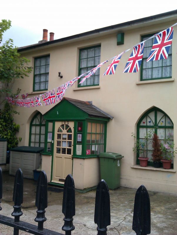
Houses. Early C19, possibly extended C20. Stucco, scored to
imitate ashlaring. Roofs of slate. Motor house in 2-storey
extension to left of No.194 appears to be C20.
3 houses conceived of as a unit, with end units originally
identical. 2 storeys, the outer units of 3 windows each,
No.192 of one-window range. Sashes of original 6x6 and 8x8
designs to 1st-floor windows which are flat-arched.
Pointed-arched windows to ground floor with Gothick glazing of
an original design. Storey band to No.194. Stacks to rear and
party walls.
INTERIOR: not inspected.
Listing NGR: TQ3321877169
External links are from the relevant listing authority and, where applicable, Wikidata. Wikidata IDs may be related buildings as well as this specific building. If you want to add or update a link, you will need to do so by editing the Wikidata entry.


Other nearby listed buildings
