Latitude: 53.4929 / 53°29'34"N
Longitude: -2.2935 / 2°17'36"W
OS Eastings: 380626
OS Northings: 399619
OS Grid: SJ806996
Mapcode National: GBR D6B.3W
Mapcode Global: WH989.RG2M
Plus Code: 9C5VFPV4+5J
Entry Name: 21, Bolton Road
Listing Date: 20 October 1998
Grade: II
Source: Historic England
Source ID: 1386088
English Heritage Legacy ID: 471512
ID on this website: 101386088
Location: Brindle Heath, Salford, Greater Manchester, M6
County: Salford
Electoral Ward/Division: Langworthy
Parish: Non Civil Parish
Built-Up Area: Salford
Traditional County: Lancashire
Lieutenancy Area (Ceremonial County): Greater Manchester
Church of England Parish: Pendleton and Claremont
Church of England Diocese: Manchester
Tagged with: Building
SALFORD
SJ89NW BOLTON ROAD 949-1/4/14 (South West side) No.21
GV II
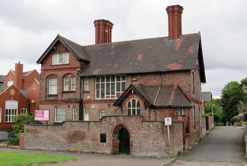
House. c1880. Blue-buff brick with red brick dressings and plain-tiled roof. 2 storeys with attic, irregular composition in domestic Gothic style. Entrance in inner face of projecting porch to right, which has hipped lean-to roof and gable facing street with wood mullioned and transomed window with leaded lights. Narrow sash windows to ground floor of central bay, and 6-light leaded mullioned and transomed window above, lighting stairs. Projecting gable to left, with wide 16-pane sash window to ground floor, and 2 shallow segmentally-arched recesses to first floor, with single and paired sash windows. 3-light mullioned casement window with small panes in apex of gable, which is ornamented with diaper brick work and tile hanging. Corbelled string course below first floor. Rear and axial stacks, with expressed shafts and corbelled caps. INTERIOR not inspected.
Listing NGR: SJ8062699619
External links are from the relevant listing authority and, where applicable, Wikidata. Wikidata IDs may be related buildings as well as this specific building. If you want to add or update a link, you will need to do so by editing the Wikidata entry.


Other nearby listed buildings