Approximate Location Map
Large Map »
Latitude: 51.2368 / 51°14'12"N
Longitude: -0.3187 / 0°19'7"W
OS Eastings: 517473
OS Northings: 149969
OS Grid: TQ174499
Mapcode National: GBR HGJ.J7Q
Mapcode Global: VHGS7.F5DP
Plus Code: 9C3X6MPJ+PG
Entry Name: Anglican Chapel at Dorking Cemetery
Listing Date: 23 June 1999
Grade: II
Source: Historic England
Source ID: 1387309
English Heritage Legacy ID: 475259
ID on this website: 101387309
Location: Pixham, Mole Valley, Surrey, RH4
County: Surrey
District: Mole Valley
Electoral Ward/Division: Dorking South
Parish: Non Civil Parish
Built-Up Area: Dorking
Traditional County: Surrey
Lieutenancy Area (Ceremonial County): Surrey
Church of England Parish: Dorking St Martin
Church of England Diocese: Guildford
Tagged with: Chapel
TQ14NE
850/10/10023
DORKING
Anglican Chapel at Dorking Cemetery
GV
II
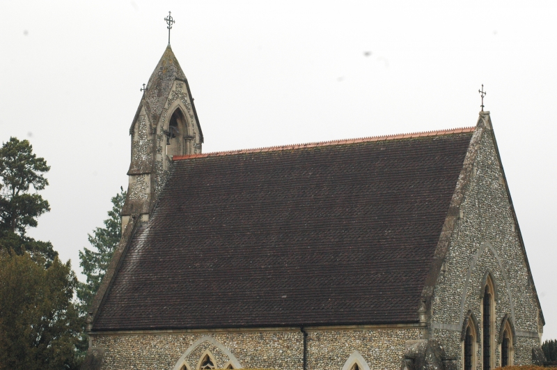
Cemetery chapel. 1856 Anglican cemetery chapel, built by Cubitt and Sons to the design of Henry Clutton. Early English style. Flint with stone dressings and tiled roof with bands of plain and fishscale tiles. Rectangular plan. West end has projecting arched entrance with corbel heads and buttressed bellcote above and buttresses to sides. Nave has one tripartite arched window under stone relieving arch and one lancet. East end has triple lancet window under stone relieving arch. One of two cemetery chapels and a combined lodge with entrance arch and mortuary chapel which are part of the same design.
Listing NGR: TQ1747349969
External links are from the relevant listing authority and, where applicable, Wikidata. Wikidata IDs may be related buildings as well as this specific building. If you want to add or update a link, you will need to do so by editing the Wikidata entry.


Other nearby listed buildings
