Latitude: 54.5848 / 54°35'5"N
Longitude: -1.0021 / 1°0'7"W
OS Eastings: 464587
OS Northings: 521526
OS Grid: NZ645215
Mapcode National: GBR PHFF.V7
Mapcode Global: WHF87.L101
Plus Code: 9C6WHXMX+W4
Entry Name: Tofts Farmhouse and Attached Garden Walls
Listing Date: 29 January 1996
Grade: II
Source: Historic England
Source ID: 1387539
English Heritage Legacy ID: 475512
ID on this website: 101387539
Location: Redcar and Cleveland, North Yorkshire, TS12
County: Redcar and Cleveland
Civil Parish: Saltburn, Marske and New Marske
Traditional County: Yorkshire
Lieutenancy Area (Ceremonial County): North Yorkshire
Church of England Parish: Marske-in-Cleveland St Mark
Church of England Diocese: York
Tagged with: Farmhouse
SALTBURN, MARSKE AND NEW MARSKE
NZ6421NE MARSKE ROAD, Marske 802-1/6/10 (North side (off)) 29/01/96 Tofts Farmhouse and attached garden walls
GV II
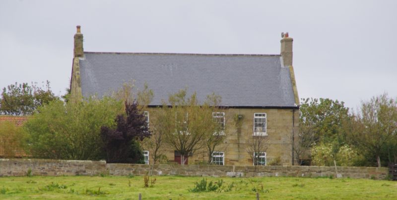
Farmhouse and garden walls attached. Mid C18 with early C19 and later alterations. House coursed squared sandstone with plinth and ashlar dressings; Welsh slate roof with stone gable coping and stone chimneys. Garden walls extend forward from left end of house and to right from right end, returning to enclose garden: brick and stone, with flat stone coping. EXTERIOR: 2 storeys, 5-window range. Central 6-panel door with 4-pane overlight under flat stone lintel; plain reveals. Similar reveals and lintels to C19 sashes, some renewed, with glazing bars and painted projecting stone sills. Steeply pitched roof has end gable coping and end chimneys with band cornices. Inserted glazed roof panels. INTERIOR: half-glazed inner door with glazing bars; raised and fielded panelled shutters to windows of ground-floor front left room; front right room has stucco cornice and fluted frieze. 6-panel doors with panelled reveals. Central dogleg stair probably mid C19 with close string, thick stick balusters, turned newel and rounded handrail. SUBSIDIARY FEATURES: garden walls mostly stone, but brick at left where formerly an outhouse was attached; ramped at left up to brick section; boarded door at left under flat stone lintel, adjacent to house. HISTORY: the farm probably served the needs of the expanding market created by the development of the nearby ironstones mine by the Pease family in the mid C19. This is an unusually complete example of a developed farm.
Listing NGR: NZ6458721526
External links are from the relevant listing authority and, where applicable, Wikidata. Wikidata IDs may be related buildings as well as this specific building. If you want to add or update a link, you will need to do so by editing the Wikidata entry.


Other nearby listed buildings