Latitude: 54.5848 / 54°35'5"N
Longitude: -1.0026 / 1°0'9"W
OS Eastings: 464559
OS Northings: 521519
OS Grid: NZ645215
Mapcode National: GBR PHFF.R8
Mapcode Global: WHF87.K1S2
Plus Code: 9C6WHXMW+WX
Entry Name: Tofts Farm: Building West of Farmhouse
Listing Date: 29 January 1996
Grade: II
Source: Historic England
Source ID: 1387541
English Heritage Legacy ID: 475514
ID on this website: 101387541
Location: Redcar and Cleveland, North Yorkshire, TS12
County: Redcar and Cleveland
Civil Parish: Saltburn, Marske and New Marske
Traditional County: Yorkshire
Lieutenancy Area (Ceremonial County): North Yorkshire
Church of England Parish: Marske-in-Cleveland St Mark
Church of England Diocese: York
Tagged with: Agricultural structure
SALTBURN, MARSKE AND NEW MARSKE
NZ6421NE MARSKE ROAD, Marske 802-1/6/11 (North side (off)) 29/01/96 Tofts Farm: building west of farmhouse
GV II
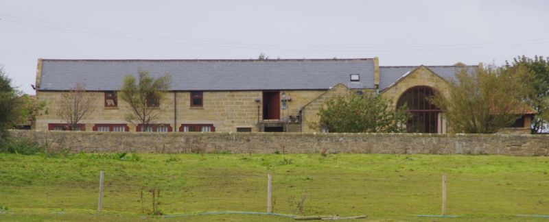
Cart sheds and lofts. Early C19 cart sheds with mid-late C19 cartsheds and loft. Coursed squared sandstone with ashlar dressings; roofs Welsh slate to cartshed and loft, pantiles to others, with stone ridges. L-plan. EXTERIOR: cart shed and loft 2 storeys, 6 bays, continuing from part of earlier building at right which formerly continued to farmhouse gable; stop chamfers to square piers forming 4 cart shelters at left, the first with boarded wood doors and the other 3 with partly glazed hit-and-miss ventilators above with projecting stone sills. At right of fifth bay a stone platform to boarded loft door is reached by stone steps alongside adjacent cartshed; sixth bay has short cartshed breaking forward with blank side wall, with front double boarded doors in high round stone arch. To right a second cartshed, longer and higher, has similar doors to front elevation. Behind this the remaining section of the earlier building. INTERIOR: not inspected. HISTORY: the farm probably served the arising needs of the expanding market created by the development of the nearby ironstones mines by the Pease family in the mid C19. This is an unusually complete example of a developed farm.
Listing NGR: NZ6455921519
External links are from the relevant listing authority and, where applicable, Wikidata. Wikidata IDs may be related buildings as well as this specific building. If you want to add or update a link, you will need to do so by editing the Wikidata entry.


Other nearby listed buildings