Latitude: 51.8997 / 51°53'58"N
Longitude: -2.0762 / 2°4'34"W
OS Eastings: 394851
OS Northings: 222350
OS Grid: SO948223
Mapcode National: GBR 2M4.XK8
Mapcode Global: VH947.YJR2
Plus Code: 9C3VVWXF+VG
Entry Name: 50, Promenade
Listing Date: 5 May 1972
Grade: II
Source: Historic England
Source ID: 1387634
English Heritage Legacy ID: 475620
ID on this website: 101387634
Location: Cheltenham, Gloucestershire, GL50
County: Gloucestershire
District: Cheltenham
Electoral Ward/Division: College
Parish: Non Civil Parish
Built-Up Area: Cheltenham
Traditional County: Gloucestershire
Lieutenancy Area (Ceremonial County): Gloucestershire
Church of England Parish: Cheltenham, St Mary with St Matthew
Church of England Diocese: Gloucester
Tagged with: Building
CHELTENHAM
SO9422SE PROMENADE 630-1/13/738 (South East side) 05/05/72 No.50
GV II
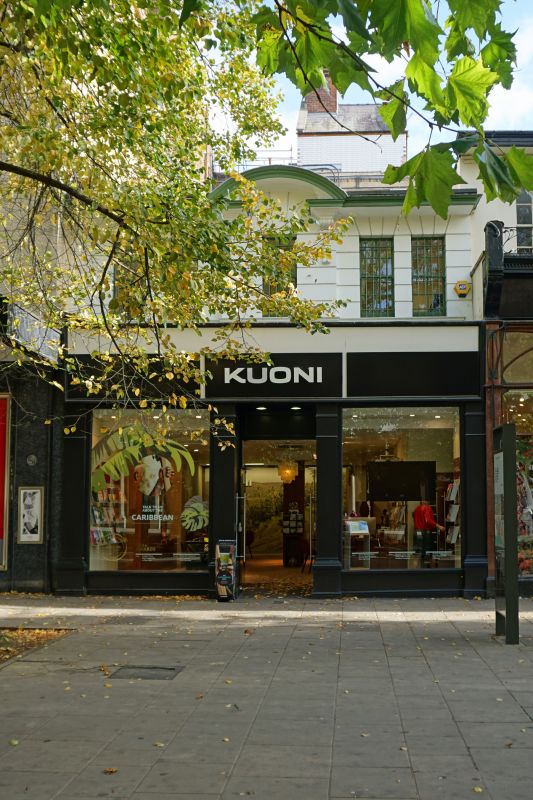
House now shop. c1820-40 with conversion to shop probably pre-1845 and later alterations including c1980s ground-floor shop front. Stucco over brick with concealed roof. EXTERIOR: 2 storeys, 5 first-floor windows. Central breakforward. Stucco detailing includes horizontal rustication to first floor; voussoirs over windows. 4/4 sashes in plain reveals and with sills. Wide eaves and central broken segmental pediment on corbel brackets and with swags. Glazed shop front with central entrance. INTERIOR: not inspected. HISTORICAL NOTE: The Promenade was laid out in 1818 as a tree-lined avenue from the Colonnade in the High Street to the Sherborne Spa (on the site of the Queen's Hotel (qv)), by 1826 it was a carriage drive with spacious gravelled walk on each side. Although originally on either side were 'rows of elegant houses', by 1845 when Rowe wrote his Cheltenham Guide (published 1850) he noted that 'nearly the whole of the left-hand (SE) side .. is devoted to professional or business establishments'. (The Buildings of England: Verey D: Gloucestershire: The Vale and The Forest of Dean: London: 1970-: 146; Williams GA: Guide Book to Cheltenham: 1824-: 29; Rowe G: Illustrated Cheltenham Guide: Cheltenham: 1850-1969: 12).
Listing NGR: SO9484722344
External links are from the relevant listing authority and, where applicable, Wikidata. Wikidata IDs may be related buildings as well as this specific building. If you want to add or update a link, you will need to do so by editing the Wikidata entry.


Other nearby listed buildings