Approximate Location Map
Large Map »
Latitude: 51.8851 / 51°53'6"N
Longitude: -2.088 / 2°5'16"W
OS Eastings: 394036
OS Northings: 220727
OS Grid: SO940207
Mapcode National: GBR 2MB.T2L
Mapcode Global: VH947.RWH8
Plus Code: 9C3VVWP6+2Q
Entry Name: Greenfield
Listing Date: 2 October 1969
Grade: II
Source: Historic England
Source ID: 1388022
English Heritage Legacy ID: 476019
ID on this website: 101388022
Location: The Park, Cheltenham, Gloucestershire, GL50
County: Gloucestershire
District: Cheltenham
Electoral Ward/Division: Park
Parish: Non Civil Parish
Built-Up Area: Cheltenham
Traditional County: Gloucestershire
Lieutenancy Area (Ceremonial County): Gloucestershire
Church of England Parish: Leckhampton St Philip and St James
Church of England Diocese: Gloucester
Tagged with: Building
CHELTENHAM
SO9420NW THE PARK
630-1/26/910 (South East side)
02/10/69 No.35
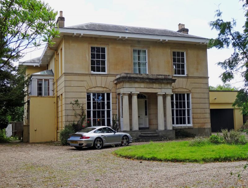
Greenfield
GV II
Villa. c1833-50 with late C19 conservatory to rear. Ashlar
over brick with hipped slate roof, tall ashlar side and rear
stacks. L-shaped on plan.
EXTERIOR: 2 storeys, with attic to rear, 3 first-floor
windows. Ashlar detailing includes horizontal rustication to
ground floor drawn into voussoirs over segmental arch to
window, tooled first-floor band, first-floor windows have
tooled architraves. Plinth. Flight of 4 roll-edged steps to
central entrance a 4-panel door with sidelights and cambered
light within porch with 2 pairs of Doric columns with
architrave, frieze with triglyphs and metopes, cornice and
blocking course; glazing to sides has margin-lights.
Ground-floor windows are tripartite with 6/6 between 2/2
sashes, elliptical arch over. First floor has 6/6 sashes. Wide
eaves on brackets. Rear retains 6/6 and 8/8 sashes; attic has
3/3 sashes.
INTERIOR: not inspected.
HISTORICAL NOTE: The Park had been laid out by 1833 by its
owner Thomas Billings as an oval tree-lined drive with a
central park which for a short period in the mid-C19 became a
zoological garden. In 1839 the development was bought by
Samuel Daukes who continued the building. One of the principal
developments influenced by White's and Nash's schemes for
Regent's Park, (1809-11) London.
A similar Papworth-derived design to Nos 37 (Arundel Lodge)
and 55 (qqv) The Park.
(Sampson A and Blake S: A Cheltenham Companion: Cheltenham:
1993-: 36,92; Merrett HS: Plan of the Town of Cheltenham:
1834-; Girouard M: The English Town: 1990-: 270-271).
Listing NGR: SO9403420721
External links are from the relevant listing authority and, where applicable, Wikidata. Wikidata IDs may be related buildings as well as this specific building. If you want to add or update a link, you will need to do so by editing the Wikidata entry.


Other nearby listed buildings
