Latitude: 50.3653 / 50°21'55"N
Longitude: -4.1785 / 4°10'42"W
OS Eastings: 245159
OS Northings: 53981
OS Grid: SX451539
Mapcode National: GBR R4D.CG
Mapcode Global: FRA 2842.FZ8
Plus Code: 9C2Q9R8C+4J
Entry Name: Covered Slip (S 180)
Listing Date: 13 August 1999
Grade: II*
Source: Historic England
Source ID: 1388431
English Heritage Legacy ID: 476442
Also known as: Slip No 1 (The Covered Slip), South Yard, Devonport Dockyard
Covered Slip Number 1, Devonport
Number 1 Covered Slip
ID on this website: 101388431
Location: Mount Wise, Plymouth, Devon, PL1
County: City of Plymouth
Electoral Ward/Division: Devonport
Parish: Non Civil Parish
Built-Up Area: Plymouth
Traditional County: Devon
Lieutenancy Area (Ceremonial County): Devon
Tagged with: Slipway Architectural structure
SX 4554 SW PLYMOUTH SOUTH YARD, Devonport Dockyard
740-1/98/215 No.1 Covered Slip (5 180)
GV II*
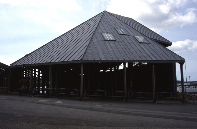
Slip and slip cover. 1770s slip, cover 1814 designed by Sir Robert Seppings. Timber frame with metal sheet mansard roof, and limestone and granite slip. Apsidal aisled plan. Open E gable formed by one of the frames, the S side open below the roof, the N side butts against the Dockyard retaining wall (qv). The slip has raking sides and curved end with two steps, with the entrance opening into the river.
INTERIOR: timber frame has composite stanchions to cantilevered principal rafters which extend out each side, with raking braces and braced horizontal collars, and 2 outer struts.
HISTORY: covers for slips were introduced into Naval dockyards to protect wooden ships during construction, and "between 1814 and 1821 most of the dry docks and all the slips (at Devonport) had graceful timber framed housings added" (Coad). Two survive here and the largest one is at Chatham (qv). They were when built the widest span roofs in Britain, and the widest in the world except for riding schools in Germany and Russia. As such they prefigured the iron slip covers of the 1840s, and subsequent railway sheds.
(Sources: The Newcommen Society: Sutherland RFM: Shipbuilding and the Long Span Roof: London: 1989: 7; Coad J: Historic Architecture of the Royal Navy: London: 1983: 71).
Listing NGR: SX4515953981
External links are from the relevant listing authority and, where applicable, Wikidata. Wikidata IDs may be related buildings as well as this specific building. If you want to add or update a link, you will need to do so by editing the Wikidata entry.


Other nearby listed buildings