Approximate Location Map
Large Map »
Latitude: 53.2273 / 53°13'38"N
Longitude: -0.5409 / 0°32'27"W
OS Eastings: 497501
OS Northings: 371025
OS Grid: SK975710
Mapcode National: GBR FMQ.N2Q
Mapcode Global: WHGJ5.N4MP
Plus Code: 9C5X6FG5+WJ
Entry Name: 319 High Street
Listing Date: 8 July 1991
Last Amended: 13 June 2022
Grade: II
Source: Historic England
Source ID: 1388590
English Heritage Legacy ID: 486035
ID on this website: 101388590
Location: Lincoln, Lincolnshire, LN5
County: Lincolnshire
District: Lincoln
Electoral Ward/Division: Park
Parish: Non Civil Parish
Built-Up Area: Lincoln
Traditional County: Lincolnshire
Lieutenancy Area (Ceremonial County): Lincolnshire
Church of England Parish: Lincoln St Mary-le-Wigford
Church of England Diocese: Lincoln
Tagged with: Building
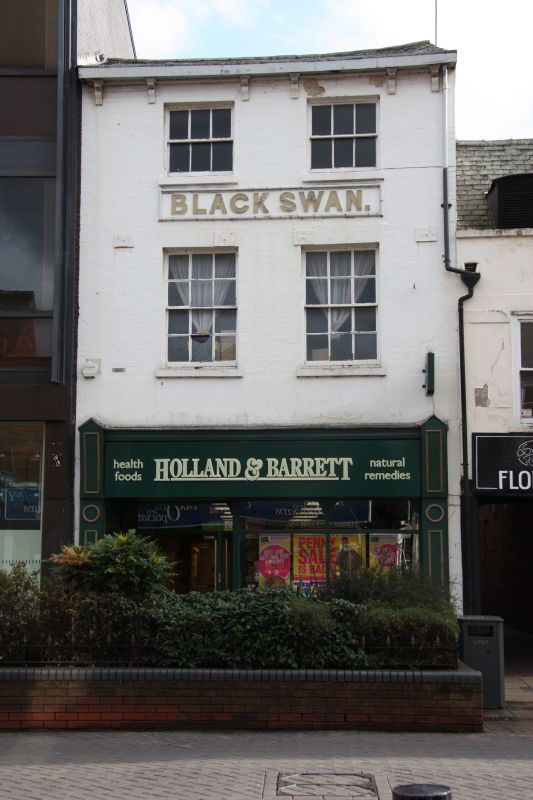
Former public house, constructed during the early C19.
Former public house, constructed during the early C19.
MATERIALS: the building is of painted and exposed red brick with a timber shopfront and a roof covering of slate.
PLAN: square on plan, the building’s principal elevation faces north.
EXTERIOR: the principal range is of three storeys across two bays onto the High Street, under a pitched roof sloping towards the primary, west façade. The ground floor contains a late-C20 timber shopfront in an early-C20 style. The first and second floors are of painted white brickwork. Each floor contains a pair of historic sash windows under painted, flat-arched heads, those on the first floor are six-over-six sashes and those on the second floor are three-over-three sashes. Between the two sets of windows is a moulded panel bearing the raised lettering: BLACK SWAN. At the roof junction is a late C20 or C21 timber soffit supported on stucco or stone corbels arranged in three pairs. There are four square-headed pattress plates in line with the first-floor window heads. The southern gable wall, visible from the High Street, is of white painted render. A passageway in the ground floor of the adjacent property (320 High Street) leads to a rear range running east from the principal, western range of number 319. This rear range steps down in stages from three storeys to one storey. The two westernmost elements, of three storeys and two storeys are of the mid- to late C19 and of matching design, constructed in red brick with timber sash windows and pitched, slate roofs. The easternmost range is a single-storey, flat-roofed element, probably of the mid- to late C20.
Listing NGR: SK9750171025
Lincoln High Street is part of the major Roman road, Ermine Street, linking London to York. It has served as the principal route into the city from the south since the first century when a legionary fortress was established on what is now ‘Uphill’ Lincoln (the vicinity of the cathedral and castle). The fortress was later transformed into a civilian settlement, taking the name Colonia Lindum, from which its modern name is derived. The Roman town gradually expanded south along Ermine Street beyond the River Witham. This development pattern was largely re-established after the Vikings resettled the city during the C9. By the time of the Norman Conquest, both sides of Ermine Street appear to have been developed for some distance south of the river, but as late as the C18, development to the east and west of the High Street was mostly limited to the areas of the castle and cathedral in ‘Uphill’ Lincoln and along the riverfront in ‘Downhill’ Lincoln.
The land south of the River Witham witnessed considerable industrial and commercial growth during the late C18 and C19. The land to the east and west of the High Street was transformed into a network of workshops, factories and yards, a trend reinforced by the arrival of the Midland Railway in 1846, followed by the Great Northern Railway in 1848, which transformed a large swathe of the area into a complex of railway buildings, storehouses and sidings. The High Street witnessed gradual redevelopment throughout this period, creating the largely C19 streetscape seen today, although a significant number of pre-industrial buildings have survived, often hidden behind later facades.
319 High Street is a former public house constructed during the early C19, probably on the site of an earlier building. The establishment was trading as the Black Swan as early as 1826 when it is first listed in a local street directory. It operated as a pub until the early 1970s. The building has a late-C20 timber shopfront. There are four square-headed pattress plates on the principal façade, possibly of the C20. The overall form of the building appears to have changed little since construction, the only substantive addition to the building footprint being a single-storey, flat-roofed extension to the rear, east range during the mid- to late C20. The building is now in use as a shop.
Legacy Record – This information may be included in the List Entry Details.
External links are from the relevant listing authority and, where applicable, Wikidata. Wikidata IDs may be related buildings as well as this specific building. If you want to add or update a link, you will need to do so by editing the Wikidata entry.


Other nearby listed buildings
