Approximate Location Map
Large Map »
Latitude: 53.2259 / 53°13'33"N
Longitude: -0.5431 / 0°32'35"W
OS Eastings: 497358
OS Northings: 370861
OS Grid: SK973708
Mapcode National: GBR FMQ.MJD
Mapcode Global: WHGJ5.M5LT
Plus Code: 9C5X6FG4+9Q
Entry Name: St Mark's Church Hall
Listing Date: 8 July 1991
Last Amended: 13 June 2022
Grade: II
Source: Historic England
Source ID: 1388751
English Heritage Legacy ID: 486212
ID on this website: 101388751
Location: New Boultham, Lincoln, Lincolnshire, LN5
County: Lincolnshire
District: Lincoln
Electoral Ward/Division: Boultham
Parish: Non Civil Parish
Built-Up Area: Lincoln
Traditional County: Lincolnshire
Lieutenancy Area (Ceremonial County): Lincolnshire
Church of England Parish: Lincoln St Mary-le-Wigford
Church of England Diocese: Lincoln
Tagged with: Architectural structure
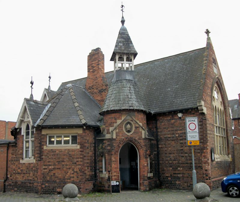
Former Sunday school and church hall, constructed in 1875 to designs by William Watkins (1832-1926), converted to a shop during the early 1970s.
Former Sunday school and church hall, constructed in 1875 to designs by William Watkins (1832-1926), converted to a shop during the early 1970s.
MATERIALS: the building is of red and dark brown brick with stone dressings, timber details and a roof covering of slate.
PLAN: the building is of one to two storeys on an irregular, L-shaped plan. The overall form comprises a rectangular hall orientated north-south with a steeply-pitched roof, from which a lower, canted cross wing projects to the west under a hipped roof. The return angles between the canted projection and hall are partially built-in, and a brick chimney stack rises between the canted projection and the main hall.
EXTERIOR: The building is designed in a High Victorian Gothic Revival style. The south gable contains a stone window with two transoms running through five lancets, and three cusped lights above, with a stone hood mould. Above this is a stone plaque bearing the letters: HÆC ÆDES STRUCTA EST IN MEMORIAM IOANNIS WOULD LEE A D MDCCCLXXV. Directly above this are three unglazed slit openings. The gable’s western edge is chamfered and rises to a moulded stone kneeler. The gable is formed of tumbled-in brickwork, rising to a stone finial. The north gable end wall is, by contrast, plainly finished with an oculus window with timber or metal glazing. A tall, gabled dormer with a finial, containing a timber, three-light mullion window breaks through the eaves perpendicular to the north gable end wall. Beneath this window, the northern return angle between the canted projection and the hall is infilled with a single-storey, flat-roofed element, partially rebuilt in mid- to late C20 brickwork.
The western face of the canted projection contains a gabled dormer breaking through the eaves, of a similar design to the larger dormer to the main hall, containing a two-light mullion window. The south-west face of the canted projection contains a four-light fixed window with a stone lintel and sill.
In the southern return angle between the canted projection and hall is a polygonal porch with a chamfered doorway flanked by small, single-light windows, with a carved stone crest of a bishop’s mitre above. The porch rises into a short, round tower with a conical roof topped with a square, timber belfry with a spirelet and finial.
Listing NGR: SK9735870861
Lincoln High Street is part of the major Roman road, Ermine Street, linking London to York. It has served as the principal route into the city from the south since the first century when a legionary fortress was established on what is now ‘Uphill’ Lincoln (the vicinity of the cathedral and castle). The fortress was later transformed into a civilian settlement, taking the name Colonia Lindum, from which its modern name is derived. The Roman town gradually expanded south along Ermine Street beyond the River Witham. This development pattern was largely re-established after the Vikings resettled the city during the C9. By the time of the Norman Conquest, both sides of Ermine Street appear to have been developed for some distance south of the river, but as late as the C18, development to the east and west of the High Street was mostly limited to the areas of the castle and cathedral in ‘Uphill’ Lincoln and along the riverfront in ‘Downhill’ Lincoln.
The land south of the River Witham witnessed considerable industrial and commercial growth during the late-C18 and C19. The land to the east and west of the High Street was transformed into a network of workshops, factories and yards, a trend reinforced by the arrival of the Midland Railway in 1846, followed by the Great Northern Railway in 1848, which transformed a large swathe of the area into a complex of railway buildings, storehouses and sidings. The High Street witnessed gradual redevelopment throughout this period, creating the largely C19 streetscape seen today, although a significant number of pre-industrial buildings have survived, often hidden behind later facades.
The former St Mark’s Church Hall was built in 1875 as St Mark’s Parochial School to designs by the local architect, William Watkins (1832-1926). When built, it lay a short distance north of St Mark’s Church, one of Lincoln’s medieval parish churches which had been completely rebuilt in 1871. The school was known as St Mark’s Sunday School by 1913, and remained in ancillary use to nearby St Mark’s Church until the mid-C20, being labelled as St Mark’s Church Hall on the 1967 OS map. In 1972, after many years of redundancy, St Mark’s Church was demolished and the Church Hall passed to the RSPCA who continue to use the building as a shop.
The building appears to have changed very little since construction. A small section of the building’s west elevation appears to have been rebuilt during the mid- to late C20.
Legacy Record – This information may be included in the List Entry Details.
External links are from the relevant listing authority and, where applicable, Wikidata. Wikidata IDs may be related buildings as well as this specific building. If you want to add or update a link, you will need to do so by editing the Wikidata entry.


Other nearby listed buildings
