Approximate Location Map
Large Map »
Latitude: 52.9828 / 52°58'58"N
Longitude: -0.0307 / 0°1'50"W
OS Eastings: 532306
OS Northings: 344643
OS Grid: TF323446
Mapcode National: GBR JW8.YXB
Mapcode Global: WHHLQ.H9L4
Plus Code: 9C4XXXM9+4P
Entry Name: Witham Tavern Public House
Listing Date: 14 February 1975
Grade: II
Source: Historic England
Source ID: 1389077
English Heritage Legacy ID: 486540
Also known as: Witham Tavern
The Witham Tavern, Boston
ID on this website: 101389077
Location: Boston, Lincolnshire, PE21
County: Lincolnshire
District: Boston
Electoral Ward/Division: Witham
Parish: Non Civil Parish
Built-Up Area: Boston
Traditional County: Lincolnshire
Lieutenancy Area (Ceremonial County): Lincolnshire
Church of England Parish: Boston St Botolph
Church of England Diocese: Lincoln
Tagged with: Pub
BOSTON
TF3244NW WITHAM BANK
716-1/4/249 (East side)
14/02/75 Witham Tavern Public House
GV II
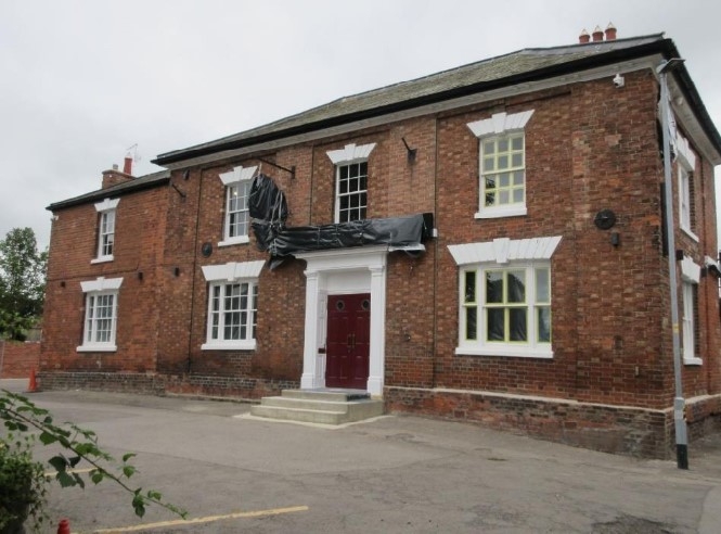
Public house. Early C19, altered later C19. Red brick in
Flemish bond, hipped slate roof, rear wall stack.
EXTERIOR: 2 storeys, 3-bay front, with plinth and overhanging
eaves on paired brackets, arranged with shallow brick
pilasters at ends and between bays. To ground floor a pair of
double panelled doors with blocked overlight are set in a
pilastered timber surround with cornice, flat hood and
panelled ingoes?. Flanked by single tripartite sashes, that on
the left with glazing bars. Above are 3 glazing bars sashes.
To the left a slightly set back later C19 single bay, with
tripartite sash and glazing bar sash above. To the right-hand
end a broad shallow recess contains a tripartite sash to
ground floor, and double sash to 1st floor. Window openings
have rusticated stucco flat arches with keystones, and
roundels to fluted mullions on the tripartite windows.
INTERIOR: not inspected.
HISTORY: the inn was recorded as first licensed in 1765,
presumably an earlier building on this site, and would date
from the construction of the nearby Grand Sluice.
Listing NGR: TF3230644643
External links are from the relevant listing authority and, where applicable, Wikidata. Wikidata IDs may be related buildings as well as this specific building. If you want to add or update a link, you will need to do so by editing the Wikidata entry.


Other nearby listed buildings
