Approximate Location Map
Large Map »
Latitude: 54.0811 / 54°4'51"N
Longitude: -0.1871 / 0°11'13"W
OS Eastings: 518700
OS Northings: 466538
OS Grid: TA187665
Mapcode National: GBR WP47.9S
Mapcode Global: WHHF7.3P67
Plus Code: 9C6X3RJ7+C5
Entry Name: North Pier and Crane Wharf, Bridlington Harbour
Listing Date: 10 January 2001
Last Amended: 8 November 2017
Grade: II
Source: Historic England
Source ID: 1389155
English Heritage Legacy ID: 486778
ID on this website: 101389155
Location: Bridlington, East Riding of Yorkshire, YO15
County: East Riding of Yorkshire
Civil Parish: Bridlington
Built-Up Area: Bridlington
Traditional County: Yorkshire
Lieutenancy Area (Ceremonial County): East Riding of Yorkshire
Church of England Parish: Bridlington Quay Christ Church
Church of England Diocese: York
Tagged with: Building
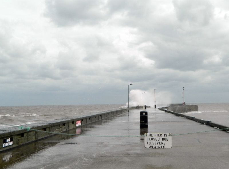
Pier forming the eastern side of Bridlington Harbour along with Crane Wharf, the quayside forming the northern side of the harbour. The wharf and pier were built 1816-1843, the pier being extended by Sir John Coode in 1866.
Harbour installations of 1816-1843 with a southern extension added to the pier in 1866 by Sir John Coode.
MATERIALS: substantial sandstone ashlar blocks, the southern extension built of pre-cast concrete blocks, the pier having a chalk-filled core. The foundations of the middle section incorporate iron sheet piles.
LAYOUT: the pier forms the eastern side of the harbour, extending about 170m south-south-east, with the 1866 extension projecting about 35m further to the south-south-west. A flight of steps extends southwards down to the harbour bed from the landward, northern end of the pier. Crane Wharf extends from the pier about 50m westwards, forming the eastern end of the north side of the harbour, incorporating a stone jetty about 7m wide extending nearly 10m into the harbour. The open framework extension* to this jetty is not of special interest. The stone jetty is flanked by stone steps down to landings that also provide access to a pair of latrines built into the quayside walling. The landward end of the pier is linked to the cliff-top street level by a semi-circular flight of steps; a further set of steps, linking the pier to the seafront promenade, are to the east.
FORM: Crane Wharf: the quayside of the eastern part of Crane Wharf is topped by iron railings. Its stone ashlar is continuous with that of the steps that lead down from the landward end of the pier to the harbour bed. The stone jetty and the western portion of Crane Wharf are also built of stone ashlar. The quayside, although no longer continuously paved with stone, does retain a few, substantial, stone paving slabs still exposed as part of its surfacing.
Pier: the sides of the main portion of the pier are smoothly battered without steps between the courses, the eastern, seaward face having a wave return coving or cordon topped by a parapet of substantial stone blocks. The northern section of the western face of this parapet is moulded, imitating timber panelling. On the seaward side of the middle section of the pier, the tops of the original iron sheet piling are exposed to view at low tide. The 1866 extension to the pierhead is also battered with a slight, stepped curve, by having the blockwork step inwards with each course, the four top courses being vertical, lacking a wave return coving. Instead the parapet is double height, being broadly stepped on its western side.
FITTINGS: extending southwards, roughly down the centre line of the pier, there is a series of cast iron features: a drum with a compass top supporting a post topped by a fish-shaped weathervane; a ring-topped cylindrical bollard; a flanged drum thought to be the base for a flag pole; a capstan; two rounded, ring-topped bollards; and a fairlead that is set at the very end of the pier, this being in the form of a short, octagonal bollard with a rope guide. The harbour light* set on the pierhead is a steel and fibreglass structure modelled on the C19 original, being in the form of a lantern-topped fluted column set on a plinth. Along the eastern, harbour face of the pier is a regular run of substantial late C19 mooring pins. Forming a kerb between these mooring pins are bind rails* formed from cast concrete: these, along with other C20 items of street furniture such as benches*, lights*, bins*, and a statue* are not of special interest.
* Pursuant to s1 (5A) of the Planning (Listed Buildings and Conservation Areas) Act 1990 (‘the Act’), it is declared that certain features are not of special architectural or historic interest: The broad timber stepped landing stage, the open framework jetty forming the extension to the stone jetty to Crane Wharf, and the sheet piled quayside to the west are all C20 alterations that are not of special interest and are not included in the mapped extent of the listing. Features within the mapped area of the listing which are also C20 and later alterations such as the harbourside concrete kerbing, benches, lights, bins, a statue and the steel and fibre glass harbour light are also excluded from the listing.
Bridlington Harbour
The mouth of the Gypsey Race river is thought to have been used by shipping from antiquity, with owners of the port being known from before the Norman Conquest, and the harbour being documented from 1113 when it was granted to the Augustinian Priory at Bridlington. Taken over by the Crown at the Dissolution, the piers enclosing the harbour were rebuilt in 1538 as rock-filled timber frameworks. Constant erosion by the sea at the landward end of both piers required frequent additions to the structures to reconnect them to the retreating cliffs. A board of commissioners were established by an Act of Parliament in 1697 to take responsibility for the harbour: this board pursued various schemes of rebuilding and improvement. Increased shipping from the tropics brought with it 'ship worm' (Teredo Nevalis) which attacked the structural timbers of the piers: this increased maintenance costs, prompting various remedial schemes, ultimately leading to the C19 reconstruction of the piers using stonework.
By the early C19, Bridlington Harbour was busily engaged in trade, supported a small amount of ship and boat building, and serviced the coastal traffic plied by colliers between the North East and London. Following other Acts of Parliament, construction of the current North Pier started in 1816, to the design of Simon Goodrick, being completed by 1843. Improvements to Crane Wharf, the section of quay adjacent to and west of the root of the North Pier, were included in the same scheme. This work was probably completed by about 1819, being shown on John Wood’s 1828 map of Bridlington. In the first half of the C19, the western end of the harbour saw the development of what became known as Langdale’s Wharf, an area of industrial concerns that have subsequently been redeveloped. The current South Pier was built in 1843-1848 to the design of James Walker on an alignment some 75m to the south of the old pier, following the 1837 Piers and Harbours Act that authorised the doubling of the size of the harbour. Unfortunately it was found that this new alignment meant that the North Pier no longer overlapped the seaward end of the South Pier, resulting in excessive wave energy entering the harbour, making many berths unusable except in very calm weather. This problem was resolved by Sir John Coode in 1866 with the construction of the southern extension to the North Pier. The difficulties with the harbour and the arrival of the railway into Bridlington in 1846 resulted in a marked decline in trade as the export of local agricultural produce switched to the better facilities provided at the port of Hull. The railway however brought increasing numbers of tourists to Bridlington, with the harbour becoming an attraction in itself with the offer of boat trips around the bay. A small coastal fishing fleet also started to develop with small tonnages being landed at Crane Wharf which was modified in the 1870s. Gummer’s Landing, the broad slipway at the west end of the harbour, to the north of the South Pier, was added in 1885, providing further facilities used by the fishing fleet. The stepped timber landing stage at Crane Wharf first added around 1900 (but subsequently rebuilt) was mainly used for boat-tripping tourists.
Developments in the C20 included the Fish Market on the South Pier and the construction of the Chicken Run Jetty on the approximate line of the earlier South Pier. The open framework jetty extending south from the Crane Wharf’s stone jetty was also reconstructed. Most of the northern quayside of the harbour was fronted in sheet steel piling in the 1950s-1960s. The far north western portion of the harbour was infilled in 1998-1999, the outlet of the Gypsey Race being culverted.
North Pier and Crane Wharf
Construction of the North Pier started in 1816 at its southern end, being built on new foundations just west of the southern extension of the old pier which had been added in 1801-1805. Part of Crane Wharf was rebuilt in stone from 1816, along with the harbour side portion of the northern, landward end of the pier. The seaward side of this section of the pier was rebuilt in stone around 1840 over the top of an C18 stone bastion. The middle section of the pier dates to 1816-1837 and features the earliest recorded use of iron sheet piling in its construction, this being reported in professional journals in the 1820s. The 35m long southern extension to the pier added in 1866 was designed by Sir John Coode. It represents an early use of Portland cement, being built of pre-cast concrete blocks, an approach subsequently used by Coode and others elsewhere. The tide-flushed latrines built into the quayside wall either side of the Crane Wharf’s jetty are thought to date to alterations made in the 1870s. The open framework jetty, that extends south from the stone jetty, dates to 1932 and was rebuilt in 1958-1959.
The North Pier retains a range iron fittings of various types, mostly being considered to be C19, being marked on the Ordnance Survey Town Plans of 1853 (1:1056) and/or 1892 (1:500) and shown in C19 illustrations. This includes a capstan (thought to have been reused from an early C19 Man-of War), three ring-topped bollards and a shorter octagonal bollard at the southern end of the pier and the remains of a large mooring ring at the landward end: these are all thought to have been used for warping, a way of rope-hauling and guiding vessels into and out of the harbour. Just north of the capstan is the base for a flagpole (which would have been used to indicate the state of the tide), with a further cast iron base supporting a weathervane topped pole lying further to the north. The harbour light, at the southern end of the pier is a steel and fibreglass structure modelled on the original that was replaced in the 1990s. Most of the mooring pins, along the eastern side of the pier, are also thought to be C19, however the concrete surfacing and cast concrete bind rail (the harbour side kerbing) are C20 alterations.
North Pier and Crane Wharf, Bridlington Harbour, built 1816-1866, is listed Grade II for the following principal reasons:
Historic interest:
* As one of the two key structures forming Bridlington Harbour which has a long and well documented history, the extensive archive held by the Harbour Commissioners significantly contributing to the special interest.
Architectural interest:
* A well-preserved, impressive piece of C19 harbour engineering incorporating early and influential use of iron sheet piling and precast concrete blocks;
* For the good survival of a suite of pier fittings;
* An example of the work of Sir John Coode, an international authority on the design of harbour installations in the second half of the C19.
External links are from the relevant listing authority and, where applicable, Wikidata. Wikidata IDs may be related buildings as well as this specific building. If you want to add or update a link, you will need to do so by editing the Wikidata entry.


Other nearby listed buildings
