Approximate Location Map
Large Map »
Latitude: 53.8595 / 53°51'34"N
Longitude: -2.1505 / 2°9'1"W
OS Eastings: 390199
OS Northings: 440379
OS Grid: SD901403
Mapcode National: GBR FRFT.76
Mapcode Global: WHB7R.Y841
Plus Code: 9C5VVR5X+RR
Entry Name: Former Toll House, Cottage and Stable
Listing Date: 31 October 2001
Grade: II
Source: Historic England
Source ID: 1389470
English Heritage Legacy ID: 488152
ID on this website: 101389470
Location: Cotton Tree, Pendle, Lancashire, BB8
County: Lancashire
District: Pendle
Civil Parish: Colne
Built-Up Area: Colne
Traditional County: Lancashire
Lieutenancy Area (Ceremonial County): Lancashire
Church of England Parish: Colne Christ Church
Church of England Diocese: Blackburn
Tagged with: Cottage
1317/0/10158
31-OCT-01
Former Toll House, Cottage and Stable
GV
II
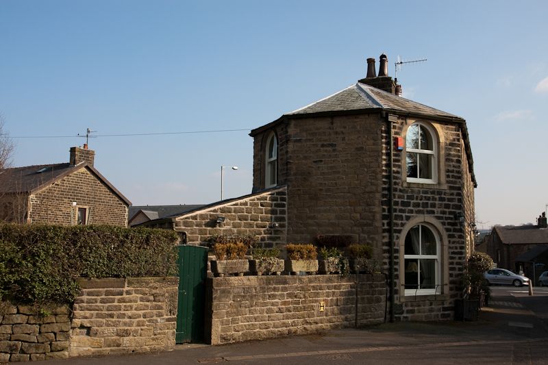
Laithe-house with attached toll house. Probably early C19. Coursed squared gritstone laid to watershot courses, grey slate hipped roof. Stone gutter brackets and two ridge stacks. 2 storeys, 5 bays comprising double-fronted house with cart-arch and stable bay to right, and a canted toll-house bay left. 1 bay deep with rear addition. Board door in plain stone surround; 9-pane windows, frames renewed. 4-centred cart arch with dressed quoins and board double doors. A round window with possibly original glazing above the cart arch. Canted bay to left: round-arched window to ground and upper floors, the ground floor window sill raised slightly. A blocked doorway [to former toll house] to left return, plain surround, and canted bay with round-arched upper window to left again. Right return: doorway to right in plain surround; to left- base of cantilevered flight of stone steps has opening to probably former dog kennel. Wide first floor doorway above, centre, in plain stone surround. Rear: ground floor not seen; a lean-to extension of coursed gritstone covers part. The stonework below the eaves to left is disturbed, suggesting a blocked window or hay loft opening; inserted window below eaves, centre; a lower single light window to right. Interior not inspected.
The laithe-house plan of house with attached barn under one roof is a typical vernacular form in the Pennines. Here the additional features of a separate first floor entrance to an apparently unheated room [right] and a separately entered toll house [left] indicate a carefully planned arrangement to meet special needs. The building stands at the foot of Lidgett, the old road between Colne and Skipton used by cattle drovers and weavers throughout the C18 which was made a Turnpike road in 1755. A second Turnpike road, to Haworth, also started from Lidgett, and the establishment of the Blackburn - Burnley - Colne turnpike in 1810 is the likely date for the construction of this toll-house. The builder possibly also provided accommodation for travellers or warehousing for cloth in this substantial building.
Dorothy Harrison [Ed] The History of Colne, Pendle Heritage Centre, 1988, p.82
Listing NGR: SD9019940379
External links are from the relevant listing authority and, where applicable, Wikidata. Wikidata IDs may be related buildings as well as this specific building. If you want to add or update a link, you will need to do so by editing the Wikidata entry.


Other nearby listed buildings
