Latitude: 51.5012 / 51°30'4"N
Longitude: -0.1677 / 0°10'3"W
OS Eastings: 527276
OS Northings: 179626
OS Grid: TQ272796
Mapcode National: GBR 6J.J0
Mapcode Global: VHGQZ.1JPH
Plus Code: 9C3XGR2J+FW
Entry Name: 9-11, Rutland Gate
Listing Date: 10 August 2004
Grade: II
Source: Historic England
Source ID: 1390971
English Heritage Legacy ID: 491661
ID on this website: 101390971
Location: Knightsbridge, Westminster, London, SW7
County: London
District: City of Westminster
Electoral Ward/Division: Knightsbridge and Belgravia
Parish: Non Civil Parish
Built-Up Area: City of Westminster
Traditional County: Middlesex
Lieutenancy Area (Ceremonial County): Greater London
Church of England Parish: Holy Trinity South Kensington
Church of England Diocese: London
Tagged with: Building
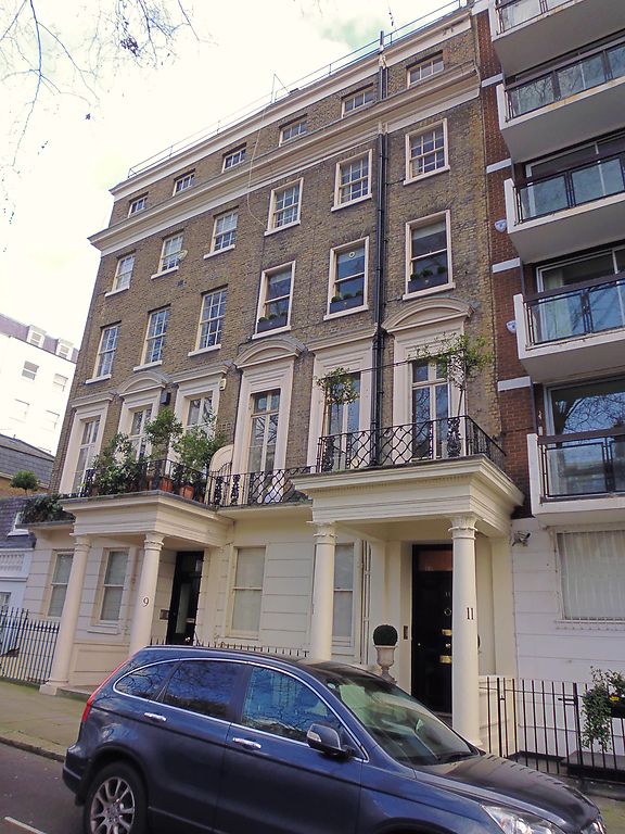
1900/0/10359 RUTLAND GATE
10-AUG-04 9-11
GV II
Pair of houses, survivors from a terrace of five, Nos 13-17 (odd) having been rebuilt. 1838-40, by John Tombs, builder, perhaps to designs by Edward Cresy the elder, Rutland House estate surveyor. Stock brick with stucco dressings. Three bays each. Four storeys, basements and full attics. Porches with distinctive palm-headed column capitals. Ground-floor channelled stucco. Panelled doors with margin lights, some altered. First-floor lattice pattern cast-iron balconies, moulded brackets at No. 9, French windows with segmental pediments to alternate architraves. Stucco cornices. Twelve-pane sashes, some plate-glass replacement. Six-light attic sashes. Spearhead cast-iron area railings.
Interiors have not been inspected.
Included for group value as part of the original layout of Rutland Gate¿s north garden square.
Sources: (ed.) John Greenacombe, Survey of London, xlv: Knightsbridge (London, 2000); Diana Burfield, Edward Cresy 1792-1858 Architect and Civil Engineer (Donington, 2003).
External links are from the relevant listing authority and, where applicable, Wikidata. Wikidata IDs may be related buildings as well as this specific building. If you want to add or update a link, you will need to do so by editing the Wikidata entry.


Other nearby listed buildings