Approximate Location Map
Large Map »
Latitude: 54.5346 / 54°32'4"N
Longitude: -1.5555 / 1°33'19"W
OS Eastings: 428862
OS Northings: 515567
OS Grid: NZ288155
Mapcode National: GBR KJL0.18
Mapcode Global: WHC5X.29K2
Plus Code: 9C6WGCMV+RR
Entry Name: Lime Cells
Listing Date: 27 November 2006
Grade: II
Source: Historic England
Source ID: 1391819
English Heritage Legacy ID: 496236
ID on this website: 101391819
Location: Hope Town, Darlington, County Durham, DL3
County: Darlington
Electoral Ward/Division: Pierremont
Parish: Non Civil Parish
Built-Up Area: Darlington
Traditional County: Durham
Lieutenancy Area (Ceremonial County): County Durham
Church of England Parish: Darlington St Matthew and St Luke
Church of England Diocese: Durham
Tagged with: Architectural structure
907/0/10025 HOPETOWN LANE
27-NOV-06 Lime cells
GV II
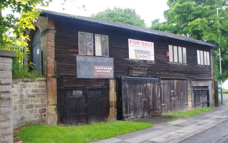
Lime Cells c. 1840s of brick and stone with stone dressings under a pitched roof of slate, faced with timber cladding.
PLAN: two-storey rectangular structure with first floor provision for railway wagons and four lime cells below on ground floor.
EXTERIOR: FRONT (WEST) ELEVATION: two storeys and four bays with projecting eaves; in filled with secondary timber cladding replacing a probable original lightweight screen. Four 4-light windows at first floor level and four double entry doors to the ground floor. GABLES: projecting eaves with an oval headed arched opening with moulded stone impost band in the centre of each gable to allow the passage of railway wagons; that through the south gable is now in filled with brick.
INTERIOR: The ground floor is divided into four separate rectangular cells in which lime was dropped from the railway wagons above and stored pending its transfer by road. The upper level comprises large timber way beams, supported on stone piers, which originally supported the railway track; the area between the former tracks, originally open, has been in filled with wooden planking. Cast iron columns support a wall plate along the main west elevation. The whole is covered by a simple truss roof with tie beams and through purlins.
HISTORY: These lime cells were constructed in the 1840's at a time of urban expansion in Darlington, which offered a ready market for building lime. They are present on the first edition Ordnance Survey map of 1855. The structure is situated at the extreme southeast corner of a site known since the 1830's as North Road and developed by the Stockton and Darlington Railway Company between 1831 and 1853. The site occupies a triangle of land between the original Stockton & Darlington railway which opened for traffic on the 27th September 1825, and a branch line to a coal depot opened on the same day. This became the location for most of the Stockton and Darlington railways subsequent development in Darlington. All of the key buildings on this site are therefore from the first generation of the Railway Age when the form and function of railway building was being developed by trial and error. Map evidence suggests that the lime cells had ceased their primary use by the end of the C19.
SOURCES: Unpublished summary of the site conservation plan (Department of Archaeology, University of York) by Robert Clarke, Museum Manager.
SUMMARY OF IMPORTANCE
This 1840's set of lime cells lies adjacent to a branch line of the Stockton & Darlington Railway and functioned as a store for building lime, delivered by rail, for use in the urban development of Darlington. It is of special interest because it falls into the important second phase of development of the railway system between 1841 and 1850 and represents a rare survival of an early and relatively intact railway related structure. It also possesses clear group value as a component of the Stockton & Darlington railway terminal complex, the world's first modern railway.
External links are from the relevant listing authority and, where applicable, Wikidata. Wikidata IDs may be related buildings as well as this specific building. If you want to add or update a link, you will need to do so by editing the Wikidata entry.


Other nearby listed buildings
