Approximate Location Map
Large Map »
Latitude: 50.9847 / 50°59'5"N
Longitude: -0.7342 / 0°44'3"W
OS Eastings: 488948
OS Northings: 121356
OS Grid: SU889213
Mapcode National: GBR DF3.17M
Mapcode Global: FRA 96BH.ZRY
Plus Code: 9C2XX7M8+V8
Entry Name: Bridge on Former Rother Navigation (At SU88942135)
Listing Date: 13 November 2007
Grade: II
Source: Historic England
Source ID: 1392319
English Heritage Legacy ID: 503084
ID on this website: 101392319
Location: Midhurst, Chichester, West Sussex, GU29
County: West Sussex
District: Chichester
Civil Parish: West Lavington
Built-Up Area: Midhurst
Traditional County: Sussex
Lieutenancy Area (Ceremonial County): West Sussex
Church of England Parish: Midhurst St Mary Magdalene and St Denis
Church of England Diocese: Chichester
Tagged with: Bridge
WEST LAVINGTON
1899/0/10052 THE WHARF
13-NOV-07 Bridge on former Rother Navigation (at
SU88942135)
II
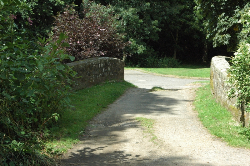
DESCRIPTION: A single rounded-headed arched bridge dating to 1794 of red, light and dark grey coloured ashlar. The arch is formed of blocks with an offset course of blocks above. On the west side of the bridge, above the offset course is a date block inscribed 'I D T C / 1794', and in the corresponding position on the east side of the bridge is a stone bust, too weather-worn to determine (the subject may well be the project's patron, the third Earl of Egremont). The parapet has a coping of tooled ashlar, and there are piers at the end of each parapet each surmounted by a chamfered coping stone.
HISTORY
It was recognised in the C18 that an alternative means of transport was needed in Sussex as the roads were notoriously bad; timber from the Weald could take up to three years to reach the shipyards. The rivers of Sussex have long been used for transport. The River Arun's lower reaches have been used for navigation since the C11, and during the reign of Queen Elizabeth I the Arun was made navigable from Littlehampton to its junction with the River Rother. Also the traditional sinuous routes of some of the county's rivers were straightened in the C16 to make them navigable. Further improvements were made in the late C18 and early C19 by building artificial cuts with locks and canals.
The canals and canalised waterways of Sussex were not comparable in size and importance with those of the Midlands and the North of England, but they were a significant part of the county's transport system for 300 years. The waterways were at their zenith in the 1830s, but the advent of the railways across West Sussex in the mid-C19 brought competition which was ultimately to sound the death knell of water-borne transport on a commercial basis. The Chichester & Arundel section of the Portsmouth & Arundel Canal was the first to become derelict in the 1850s and by 1900 only the occasional barge was present on the river and canal system.
The River Rother between Midhurst and the point where it meets the River Arun Navigation was called the Rother Navigation, and was built between 1791 and 1795 by the third Earl of Egremont so that coal could be taken to Midhurst and Petworth, and corn and timber could be exported from the area. The line of the canal was surveyed by William Jessop and for the most part it followed the natural course of the river. It had only 2 miles of artificial cuts along its total 11 ¼ mile length, and rose by 54ft with the aid of 8 locks. When the railway to Midhurst was completed in 1866 the fortune of the Rother Navigation started to decline, although it did remain in commercial use until March 1888.
The bridge at the Wharf which is the subject of this listing lies adjacent to the Canal Basin which was a sort of marina for canal traffic and a terminus of the Rother Navigation. The bridge was built in 1794 and is still in use. When commercial use ended in 1888, pleasure skiffs were kept in the Canal Basin. The bridge was restored in 1977 as part of the town's commemoration of Queen Elizabeth's Silver Jubilee.
SOURCES
P A L Vine, West Sussex Waterways (1985)
P A L Vine, London's Lost Route To Midhurst The Earl of Egremont's Navigation (1995)
REASONS FOR DESIGNATION DECISION
The Bridge at The Wharf is designated at Grade II for the following principal reasons:
* The bridge, dating to 1794, has been restored, but is essentially in original condition
* The bridge is of architectural interest in the context of both the Rother Navigation and the wider Sussex canal network
* The bridge is of historic interest as part of the national waterways system of the late C18
REASONS FOR DESIGNATION DECISION
The Bridge at The Wharf is designated at Grade II for the following principal reasons:
* The bridge, dated to 1794, has been restored, but is essentially in original condition
* The bridge is of architectural interest in the context of both the Rother Navigation and the wider Sussex canal network
* The bridge is of historic interest as part of the national waterways system of the late C18
External links are from the relevant listing authority and, where applicable, Wikidata. Wikidata IDs may be related buildings as well as this specific building. If you want to add or update a link, you will need to do so by editing the Wikidata entry.


Other nearby listed buildings
