Approximate Location Map
Large Map »
Latitude: 53.1433 / 53°8'35"N
Longitude: -1.982 / 1°58'55"W
OS Eastings: 401300
OS Northings: 360681
OS Grid: SK013606
Mapcode National: GBR 245.XC8
Mapcode Global: WHBCB.J8D4
Plus Code: 9C5W42V9+85
Entry Name: Milepost Near Upper Hulme (Ngr SK0130760681)
Listing Date: 18 December 2007
Grade: II
Source: Historic England
Source ID: 1392366
English Heritage Legacy ID: 503333
ID on this website: 101392366
Location: Upper Hulme, Staffordshire Moorlands, Staffordshire, ST13
County: Staffordshire
District: Staffordshire Moorlands
Civil Parish: Heathylee
Traditional County: Staffordshire
Lieutenancy Area (Ceremonial County): Staffordshire
Church of England Parish: Quarnford St Paul
Church of England Diocese: Lichfield
Tagged with: Milestone
418/0/10003
18-DEC-07
HEATHYLEE
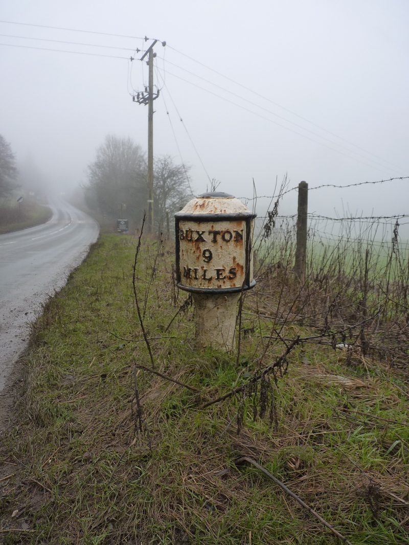
Milepost near Upper Hulme (NGR SK 01307 60681)
II
An early C19 milepost of painted cast iron. The milepost is of a 'bobbin' type, having a cylindrical head with shallow domed top, set on a short, tapered cylindrical post. The inscriptions are cast in relief; left face: LEEK 3 MILES; right face: BUXTON 9 MILES.
HISTORY
The milepost was erected by the Lee, Hassop, Middle Hills and Buxton Turnpike Trust. It was cast by William Green of Macclesfield in 1833.
REASONS FOR DESIGNATION DECISION:
The milepost on the A53 near Upper Hulme is listed at Grade II for the following reasons:
* A good example of an early C19 milepost, illustrating the standardisation of roads and the introduction of turnpikes to facilitate the transport needs of the increasingly industrial landscape of C19 Staffordshire
* This cast iron milepost is set in its original location, and is intact
SK0130060681
* A good example of an early C19 milepost, illustrating the standardisation of roads and the introduction of turnpikes to facilitate the transport needs of the increasingly industrial landscape of C19 Staffordshire
* This cast iron milepost is set in its original location, and is intact
External links are from the relevant listing authority and, where applicable, Wikidata. Wikidata IDs may be related buildings as well as this specific building. If you want to add or update a link, you will need to do so by editing the Wikidata entry.


Other nearby listed buildings
