Approximate Location Map
Large Map »
Latitude: 51.3945 / 51°23'40"N
Longitude: 0.5454 / 0°32'43"E
OS Eastings: 577182
OS Northings: 169234
OS Grid: TQ771692
Mapcode National: GBR PPQ.DQN
Mapcode Global: VHJLV.D6QV
Plus Code: 9F329GVW+Q5
Entry Name: Group of Anti-Tank Pimples
Listing Date: 28 February 2008
Grade: II
Source: Historic England
Source ID: 1392428
English Heritage Legacy ID: 504000
ID on this website: 101392428
Location: Lower Lines Park, Brompton, Medway, Kent, ME7
County: Medway
Electoral Ward/Division: Gillingham North
Parish: Non Civil Parish
Built-Up Area: Gillingham
Traditional County: Kent
Lieutenancy Area (Ceremonial County): Kent
Church of England Parish: Gillingham St Luke
Church of England Diocese: Rochester
Tagged with: Architectural structure
686-1/0/10009 MEDWAY ROAD
28-FEB-08 GROUP OF ANTI-TANK PIMPLES
GV II
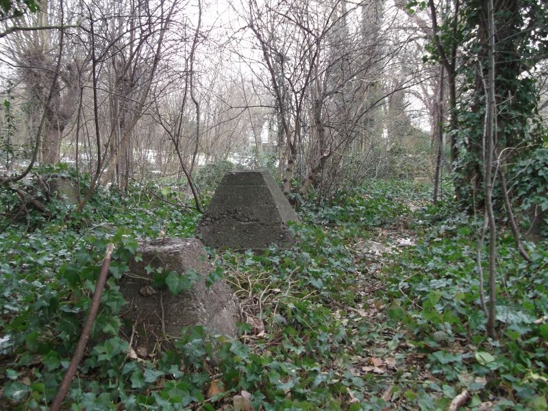
Anti-tank obstacles of pimple form, circa 1940
DESCRIPTION: Concrete anti-tank pimples (truncated pyramids also colloquially known as 'Dragon's Teeth'). Forming a south-west to north-east line approximately 85m in length along the northern side of Medway Road, to the east of Cumberland Road and to the south-east of the Chatham Lines. The pimples are five deep in places and are of the standard symmetrical form. Some, in the central part of the line, are part buried and it is assumed, given the topography, that further examples survive but are fully buried to the east. In the west of the line the anti-tank pimples are visible, although overgrown, and are a good surviving group.
HISTORY: These anti-tank obstacles were erected circa 1940 as part of the anti-invasion defences for Chatham, Gillingham and Brompton in defence of the dockyard and barracks. This line fills a gap in the existing Napoleonic defences which were adapted to form an anti-tank stop-line during the Second World War. Specifically these obstacles bridge the gap between a row of former dockyard police houses and the defended entrance to the Nore Command Bunker. (The bunker was for the Commander-in-Chief who had responsibility for protecting the entrance to the Port of London as well as traffic up and down the east coast.) The anti-tank obstacles are documented in `The Garrison Plan to Defeat Invasion' of 1941. Tactically their purpose was to prevent enemy progress but in the event that an enemy vehicle did attempt to drive across an obstacle, its vulnerable underside would be exposed to defensive fire.
CONTEXT: Anti-invasion defences have been the subject of an English Heritage Monument Protection Programme (MPP) study which looked at the known resource, drawing on the Council for British Archaeology's Defence of Britain project, and made recommendations for designation. The MPP study considerably enhanced the understanding of the resource and identified 112 examples of sites with anti-tank pimples nationally, of which 46 were considered to be good examples.
SOURCES:
National Monuments Record No. TQ76NE347
Defence of Britain Project Database site reference S0012576 at http://ads.ahds.ac.uk/catalogue/collections/blurbs/324.cfm
REASON FOR DESIGNATION DECISION: The line of World War II anti-tank pimples at Medway Road, Gillingham is designated at Grade II for the following principal reasons:
* A good surviving group of anti-tank pimples;
* One of only two known groups of anti-tank obstacles, and the better of the two, associated with the re-use of the Chatham Lines during World War II. They have group value with The Lines and the adjacent Nore Command Bunker.
REASON FOR DESIGNATION DECISION:
A line of World War II anti-tank pimples at Medway Road, Gillingham is designated at Grade II for the following principal reasons:
* A good surviving group of anti-tank pimples;
* One of only two known groups of anti-tank obstacles, and the better of the two, associated with the re-use of the Chatham Lines during World War II. They have group value with The Lines and the adjacent Nore Command Bunker.
External links are from the relevant listing authority and, where applicable, Wikidata. Wikidata IDs may be related buildings as well as this specific building. If you want to add or update a link, you will need to do so by editing the Wikidata entry.


Other nearby listed buildings
