Approximate Location Map
Large Map »
Latitude: 52.4898 / 52°29'23"N
Longitude: -1.9121 / 1°54'43"W
OS Eastings: 406067
OS Northings: 287991
OS Grid: SP060879
Mapcode National: GBR 5X5.QC
Mapcode Global: VH9YW.TP15
Plus Code: 9C4WF3QQ+W5
Entry Name: 102, Spencer Street
Listing Date: 29 April 2004
Grade: II
Source: Historic England
Source ID: 1392809
English Heritage Legacy ID: 505849
ID on this website: 101392809
Location: Hockley, Birmingham, West Midlands, B18
County: Birmingham
Parish: Non Civil Parish
Built-Up Area: Birmingham
Traditional County: Warwickshire
Lieutenancy Area (Ceremonial County): West Midlands
Church of England Parish: Birmingham St Paul
Church of England Diocese: Birmingham
Tagged with: Building
BIRMINGHAM
997/0/10352 SPENCER STREET
29-APR-04 102
II
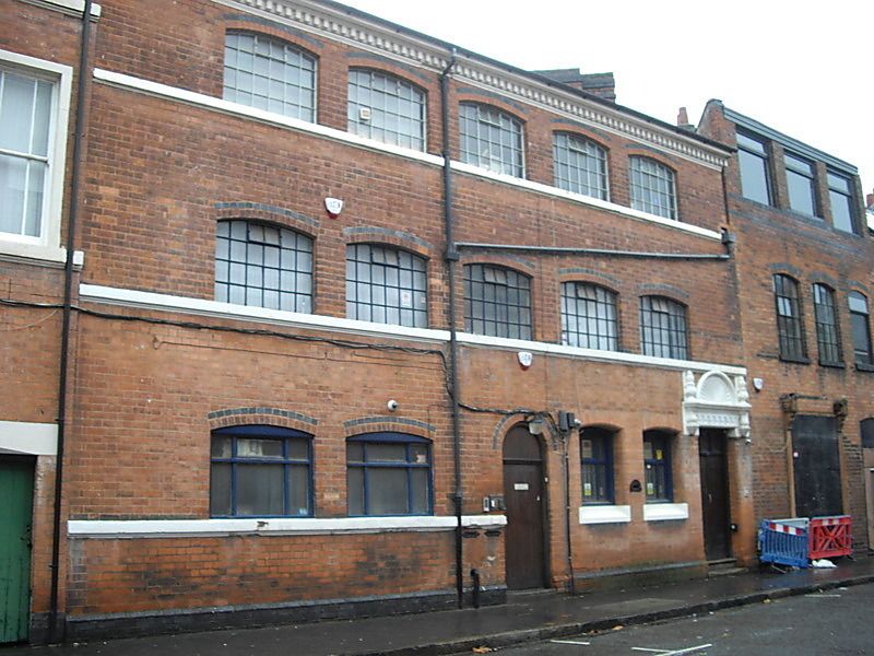
Manufactory. Late C19, partially remodelled early C20. Red brick with painted stone dressings and blue brick detailing, end brick chimneys and a slate roof covering.
PLAN: Narrow wedge-shaped street frontage plot formed at rear of garden to No. 102 Vyse Street.
EXTERIOR: 6 bay frontage range of 3 storeys, with remodelled or added entrance to right-hand end bay, with elaborate painted door head with shallow bracketed cornice and shell hood above. Vertically-planked double doors. To the left a pair of shallow rubbed brick arch -headed windows with painted sills and late C20 frames. Further left, a semi-circular arch-headed doorway with blue brick margin to arch, and 2 wide window openings with late C20 joinery on a painted sill band. Upper floors with shallow arch-headed workshop windows on painted sill bands, all with multi-pane metal window frames, and blue brick arch margins. Painted dentilled eaves course.
HISTORY: The plot on which this building stands is shown on the Piggot-Smith map of c.1862 as part of the wedge-shaped garden to a house on the not yet fully-developed frontage to Vyse Street. The 1889 Ordnance Survey map shows fully-developed frontages to Vyse Street, Spencer Street and Hockley Street, the triangular enclosure formed by these streets occupied almost completely by jewellery works. At this time, part of the Spencer Street frontage is shown to be formed by the rear workshop ranges to converted houses on Vyse Street, of which No.102 may originally have been an example.
Forms a group with Plantagenet Buildings, No. 28 Hockley Street )q.v.) and Nos. 94, 96 and 100, Spencer Street (q.v.)
A small late C19 manufactory, which may have originated as a workshop range, later remodelled to form a manufactory with office entrance and windows to accompany the earlier workshop windows of the upper floors. The site demonstrates the economic viability of small plots and restricted sites during a period of rapid expansion in a manufacturing district in Birmingham now recognised as being of international significance
External links are from the relevant listing authority and, where applicable, Wikidata. Wikidata IDs may be related buildings as well as this specific building. If you want to add or update a link, you will need to do so by editing the Wikidata entry.


Other nearby listed buildings
