Approximate Location Map
Large Map »
Latitude: 52.4872 / 52°29'13"N
Longitude: -1.9109 / 1°54'39"W
OS Eastings: 406147
OS Northings: 287697
OS Grid: SP061876
Mapcode National: GBR 5X6.Z9
Mapcode Global: VH9YW.TRN6
Plus Code: 9C4WF3PQ+VJ
Entry Name: 32-34, Warstone Lane
Listing Date: 29 April 2004
Grade: II
Source: Historic England
Source ID: 1392828
English Heritage Legacy ID: 505869
ID on this website: 101392828
Location: Brookfields, Birmingham, West Midlands, B18
County: Birmingham
Parish: Non Civil Parish
Built-Up Area: Birmingham
Traditional County: Warwickshire
Lieutenancy Area (Ceremonial County): West Midlands
Church of England Parish: Birmingham St Paul
Church of England Diocese: Birmingham
Tagged with: Building
BIRMINGHAM
997/0/10268
29-APR-04
WARSTONE LANE
32-34
II
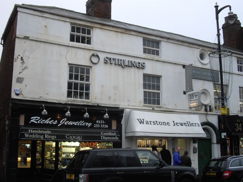
Terrace of 3 shops and offices, formerly houses, subsequently adapted and extended to form works premises. c. 1840, with late C19 alterations and additions, further altered mid-C20.
Red brick, rendered and painted to front elevation, with a hipped slated roof with off-centre ridge and right-hand gable stacks.
PLAN: 3-unit terraced frontage range with lean-to extension to rear of Nos. 32 and 33, and long storeyed workshop extension to rear of No. 34, resulting in irregular L-plan enclosing rear yard.
EXTERIOR: 3- bay frontage range of 2 storeys and attics with 3 ground floor C20 shop fronts. Off- centre to right, a semi-circular arch headed opening within a moulded surround with C20 door and overlight, formerly the passage entrance giving access to the rear yards. Above, roundels to first and attic floors, only the latter glazed. Sill bands to first and attic floors, with C20 replacement multi-pane window frames. Rear elevation with 2- phase lean-to addition and 2-storeyed workshop wing of 10 bays with upper floor doorway and flanking multi-pane workshop windows , many frames being early C20 replacements
HISTORY. The buildings are shown on the Piggot-Smith map of 1855-62 as a range of 3 houses, with the rear of No. 32 already substantially overbuilt. The 1889 Ordnance Survey map shows some development to the rear of the other 2 houses, but the long workshop range is post-1889. The 1845 Street Directory lists the occupants as private individuals and a baker.
A prominent street frontage range of C19 dwellings, adapted to manufacturing use in the late C19, and located at the centre of a manufacturing district of Birmingham now considered to be of international significance and
External links are from the relevant listing authority and, where applicable, Wikidata. Wikidata IDs may be related buildings as well as this specific building. If you want to add or update a link, you will need to do so by editing the Wikidata entry.


Other nearby listed buildings
