Approximate Location Map
Large Map »
Latitude: 50.83 / 50°49'48"N
Longitude: 0.0262 / 0°1'34"E
OS Eastings: 542787
OS Northings: 105345
OS Grid: TQ427053
Mapcode National: GBR LRT.TP7
Mapcode Global: FRA B6YX.207
Plus Code: 9F22R2JG+2F
Entry Name: Swing Bridge over River Ouse
Listing Date: 24 July 2009
Grade: II
Source: Historic England
Source ID: 1393389
English Heritage Legacy ID: 506679
Also known as: Southease Bridge
ID on this website: 101393389
Location: Southease, Lewes, East Sussex, BN8
County: East Sussex
District: Lewes
Civil Parish: Southease
Built-Up Area: Rodmell
Traditional County: Sussex
Lieutenancy Area (Ceremonial County): East Sussex
Church of England Parish: Southease St Peter
Church of England Diocese: Chichester
Tagged with: Bridge
SOUTHEASE
946/0/10050 SWING BRIDGE OVER RIVER OUSE
24-JUL-09
II
SOUTHEASE
946/0/10050 Swing bridge over River Ouse
24-JUL-09
II
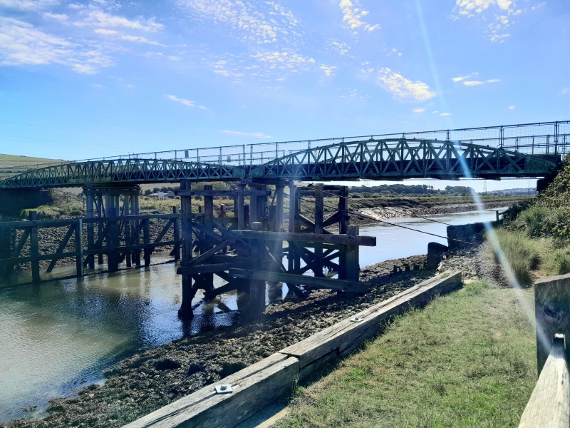
Swing bridge. 1880, designed in 1878, by Henry E Wallis (CE) of Westminster, and constructed by Shaw & Co., with C20 timber replacement and safety additions.
HISTORY
The River Ouse south of Lewes was canalised between 1791 and 1795, to create the Lower Ouse Navigation, designed by William Jessop and supervised by Cater Rand, a Lewes schoolmaster and civil engineer (Brent 1993). This work cut off a lengthy meander of the river between Itford and Durham Farms, and severed farmland, necessitating statutory provision of a bridge across the new canal at Southease. The current structure, which replaces an earlier bridge approximately 10m upstream, dates from 1880 and incorporated a swing span to permit the passage of masted vessels. The bridge was fixed in position in 1988, under parliamentary powers, to prevent large vessels sailing further up river. However, the pivot table is still in position.
DESCRIPTION
The bridge is a three-span structure, formed of wrought-iron bowstring trusses, 3.62m apart, with a total length between abutments of 43.2m. The western span of 13.8m is fixed and the remaining two spans, of 29.4m, centrally pivot to allow larger vessels passage. The ends of the bridge are carried on brick abutments with curved wing walls having projecting piers in red brick in English bond with stone copings. The embankments, the top of which are 6m wide and with a side profile of 1:1, were constructed at an incline of 1:20. The top of the embankments (and therefore the top of the bridge deck) was designed to be 2.75m above high water.
The two intermediate piers, both constructed in the waterway, are formed of groups of cast-iron columns. The columns are in two lengths, being bolted together through the flanges. The western pier between the fixed and swinging spans consists of two groups of three columns with a cast-iron capping to each, the caps being linked with a cast-iron transom girder and diagonal cross bracing. Wrought-iron tie-bars are attached to the cast-iron caps and are connected to concrete pads built into the west bank via iron shoes. One of these tie-bars has been disconnected and replaced with another that is anchored into the river bank.
The eastern pier, supporting the swinging section of the bridge, comprises eight columns surrounding a central column supporting the king post. There are cast-iron cruciform horizontal bracings linking the columns at mid-height. There is also a radial stiffening frame with eight spokes collared to the piles and with raking struts attached to the cap of the central column. The columns support the pivoting mechanism, which is based on a circular geared cast-iron rack in the form of a giant spur wheel with eight spokes. An upper cast-iron 'I'-section ring, with eight spokes, is bolted to the underside of the superstructure and between the two rings is a race of twelve unflanged wheels whose axles are attached to a wrought-iron ring; the whole acting as a turntable. The bridge was operated by a small pinion on a vertical shaft engaging with the rack, which passes up through the decking and is finished with a square-ended spigot. A 'T'-shaped capstan bar was presumably supplied by which two people could operate the bridge, but this is no longer extant.
The spans are curved (bowstring) steel 'X' pony trusses. The trusses are 14 bays long, the end ones being filled with solid plates and the rest with vertical post of paired iron tees with diagonal compression and tension members. The top booms are braced by 'U'-frames comprising rolled-steel channel cross girders beneath the deck. These appear to be a later addition.
The deck is of wrought-iron 'I'-beams, to the flanges to which rolled steel channels have been bolted at some later stage. There are longitudinal wrought-iron girders augmented by wooden intermediate beams. This all supports softwood timber decking, laid flat, open jointed and bolted to the girders. As expected the timber decking has been replaced throughout the life of the bridge and is not original. A handrail has been fitted on the tops of the trusses to raise the height of the balustrades. The original handrails, as indicated on the Wallis drawings, ran only from the third points of the trusses at the level of the summit of the bowstrings and were supported on cast-iron stanchions.
SUBSIDIARY FEATURES
There are sets of timber fender piles, upstream and downstream, to protect the east pier against shipping when the bridge is open. These each comprise three piles with intermediate and top rails and raking struts. A further row of ten piles and rails connects the upstream and downstream fenders with a raking shore to each pile. Further sets of fender piles are located upstream and downstream of the west pier, with three piles to each and with two intermediate piles between them and with rails as for the east pier.
There is a wooden boarded platform surrounding the top of the east pier carried on six joists clamped to the piles. This provided access to the operating gear for maintenance.
At each end of the bridge there are two pairs of steel gates. The gates are in a derelict state but still have the central target panel warning traffic to stop.
SOURCES
Contract with Herbert Adams Chambers of Seaford, contractor to repair the Bridge at Southease, 23 Aug 1904 - held at East Sussex Records Office, Lewes, Ref: SRA/19/2/2
Correspondence concerning Southease Bridge including damage caused by the MV Remi, Jul 1933-Sep 1941 - held at East Sussex Records Office, Lewes, Ref: SRA/8/11/24
Plans and Elevations of Southease Bridge, including detail of the turntable by Henry E Wallis, November 1878 - held at East Sussex Records Office, Lewes, Refs: SRA/8/10/2, SRA/8/10/3 and SRA/8/10/4
Blackwell, John, Sussex Main Lines, a year 2002 survey.
Various documents/letters held at the East Sussex County Highways Depot, Ringmer
Brent, Colin, Georgian Lewes 1714-1830. The Heyday of a Country Town (1993)
Constable, PA. Bridge modification, a value-for-money approach, in Pritchard B (ed), Bridge Modification 2, Thomas Telford (1997) 15-22
Landley, Michael, Sussex Shipping, sail, steam and motor (2004)
Leicester, Keith and Martin, Ron. Brighton Railway Station. Journal of the Sussex Industrial Archaeology Society, Issue 28 (1998)
Thornburn, Margaret, The Lower Ouse Valley, A history of the brookland (2007)
Environment Agency, Southease Bridge Scoping Report. Unpublished Report (2008)sussexias.co.uk/articles/main_9.htm accessed on 28 April 2009.
REASONS FOR DESIGNATION: The swing bridge over the River Ouse, Southease is listed at Grade II for the following principal reasons:
* Its special architectural interest as an intermediate sized, manually operated swing bridge of late C19 date;
* As a rare example of a structure which is usually only found within dock and industrial areas; and
* Good survival of subsidiary features, such as the timber fenders and gates, which aid understanding of the bridges operation.
External links are from the relevant listing authority and, where applicable, Wikidata. Wikidata IDs may be related buildings as well as this specific building. If you want to add or update a link, you will need to do so by editing the Wikidata entry.


Other nearby listed buildings
