Approximate Location Map
Large Map »
Latitude: 51.4866 / 51°29'11"N
Longitude: -0.0001 / 0°0'0"W
OS Eastings: 538952
OS Northings: 178297
OS Grid: TQ389782
Mapcode National: GBR L1.4N3
Mapcode Global: VHGR1.YW9S
Plus Code: 9C3XFXPX+JX
Entry Name: Setted Road Structure
Listing Date: 23 February 2010
Grade: II
Source: Historic England
Source ID: 1393679
English Heritage Legacy ID: 499611
ID on this website: 101393679
Location: Greenwich, London, SE10
County: London
District: Greenwich
Electoral Ward/Division: Peninsula
Parish: Non Civil Parish
Built-Up Area: Greenwich
Traditional County: Kent
Lieutenancy Area (Ceremonial County): Greater London
Church of England Parish: East Greenwich Christ Church, St Andrew and St Michael
Church of England Diocese: Southwark
Tagged with: Architectural structure Road surface
TQ3878
786/15/10137
23-FEB-10
LASSELL STREET
Setted Road Structure
PELTON ROAD
Setted Road Structure
BALLAST QUAY
Setted Road Structure
GV
II
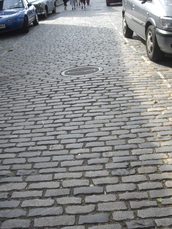
Setted road structure, 1860s and 1870s. Minor later repairs.
LOCATION: setted road structure survives on Ballast Quay and on the northernmost portions of the two roads perpendicular to its west and east ends, Lassell Street and Pelton Road. Surfaces south of where Banning Street intersects Lassell and Pelton Road not of special interest.
SETTED ROAD STRUCTURE: comprises pavements on both sides of the roads, rectangular granite kerbstones and courses of granite setts on the roads themselves. The pavements would once have been paved with large York flagstones but have long since been replaced and are now concrete. The kerbstones are less altered. The setted surface is a remarkable survival. Consistent throughout all three streets, it consists of regular, speckled grey-mauve setts 3 inches wide and 5 to 9 inches long. The coursing runs across the road surface following the curve of Ballast Quay as the street winds alongside the wharfs and changes direction to take in the corners to Lassell Street and Pelton Road. The route followed by Ballast Quay has resulted in very careful modifications to the coursing in one place to take in the curve: here some setts have been laid perpendicular to the courses. This has been expertly done and lends the setted surface considerable character. There is a band of narrower, closely-set setts at the corner of Ballast Quay and Lassell Street; these would have been swept and kept cleaner than the larger setts of the road surface and served as road crossings. Various repairs have also taken place over the years and some service trenches dug and the setts re-laid. These have been done with varying degrees of sensitivity to the original fabric, but overall the consistency of survival is noteworthy.
HISTORY: Ballast Quay and its neighbouring streets are lined with late Georgian houses. The Quay itself, formerly called Union Quay and re-named because ships with discharged cargo were laden with local gravel from this point, is shown as developed on Wyld's map of 1827. Pelton Road and Lassell Street (then called Marlborough Street) date from the 1840s and 1850s and appear on Stanford's map of 1862. All three streets were on land owned by Morden College and leased to William Coles Child, head of a prominent coal importing business, who developed the area. His firm supplied coal for domestic use from the waterfront and had a lime kiln nearby. The Coles Child Estate is likely to have instigated laying the setted road structure in the 1850s, both for the convenience of residents and to withstand the heavy industrial traffic that would have passed through these streets. The Pelton Road setts were re-laid in the 1870s by the Greenwich Board of Works.
Just downriver from Ballast Quay is Granite Wharf, once the stone-unloading point for John Mowlem's building and masonry firm. Established in 1822, Mowlem was (and remains to this day) responsible for many of the major contracting jobs of the time. Their operations moved to Granite Wharf in 1852, after the purchase on quarries in Guernsey in 1850. Worked granite setts from these quarries arrived in London via Granite Wharf and were widely used in the campaign of repaving in the capital from the 1850s. It is very likely that the setts used in the road structure of Ballast Quay and its neighbouring streets were supplied by Mowlem.
Street coverings before the mid Victorian period, where they existed at all, were usually round boulders or large, irregular pebbles. These provided some surface stability but offered little comfort for carriage passengers due to the wide joints in which filth usually collected. In 1824 the engineer Thomas Telford in a 'Report respecting the Street Pavements, &c., of the Parish of St George's, Hanover Square' had recommending laying roads with a foundation of broken stones or concrete upon which should be placed rectangular paving stones of granite, worked flat on the face and straight and square on the sides as to joint close, grouted with lime and sand. Telford suggested different sized stones for different classes of streets, ranging from 4-7 inches wide and 7-13 inches long. Transportation of granite was facilitated by the development of the railways and by the mid-century great numbers of London streets were being repaved with stone from Aberdeen, the Channel Islands and the West Country. The Metropolitan Board of Works used Telford's system in many of the new streets they laid out in the 1860s, and their example was followed by parish vestries with whom responsibility for the condition of roads lay. A modified version of Telford's specifications was used at Ballast Quay.
REASONS FOR DESIGNATION: The setted road structure in Ballast Quay, Lassell Street and Pelton Road is designated at Grade II for the following principal reasons:
* It is a rare survival of a mid-Victorian road surface in a London, notable for the consistency of its courses of granite setts and the extent of surviving setts
* It displays a high quality of workmanship, in particularly where the courses change direction where the streets meet
* It has an interesting historic context, located just upstream from Granite Wharf where a great portion of the capital's granite setts arrived in London from Guernsey from the 1850s
* There is group value within this strong ensemble which includes Grade II-listed terraced houses, the Cutty Sark Public House, and the Harbour Master's Residence.
The setted road structure in Ballast Quay, Lassell Street and Pelton Road should be designated at Grade II for the following principal reasons:
* It is a rare survival of a mid-Victorian road surface in a London, notable for the consistency of its courses of granite setts and the extent of surviving setts
* It displays a high quality of workmanship, in particularly where the courses change direction where the streets meet
* It has an interesting historic context, located just upstream from Granite Wharf where a great portion of the capital's granite setts arrived in London from Guernsey from the 1850s
* There is group value within this strong ensemble which includes Grade II-listed terraced houses, the Cutty Sark Public House, and the Harbour Master's Residence.
External links are from the relevant listing authority and, where applicable, Wikidata. Wikidata IDs may be related buildings as well as this specific building. If you want to add or update a link, you will need to do so by editing the Wikidata entry.


Other nearby listed buildings
