Approximate Location Map
Large Map »
Latitude: 51.5211 / 51°31'15"N
Longitude: -0.0995 / 0°5'58"W
OS Eastings: 531953
OS Northings: 181951
OS Grid: TQ319819
Mapcode National: GBR P8.TX
Mapcode Global: VHGR0.7188
Plus Code: 9C3XGWC2+C6
Entry Name: Setted Street Surface
Listing Date: 29 April 2010
Grade: II
Source: Historic England
Source ID: 1393770
English Heritage Legacy ID: 505906
ID on this website: 101393770
Location: St Luke's, Islington, London, EC1M
County: London
District: Islington
Electoral Ward/Division: Bunhill
Parish: Non Civil Parish
Built-Up Area: Islington
Traditional County: Middlesex
Lieutenancy Area (Ceremonial County): Greater London
Church of England Parish: St Sepulchre Holborn
Church of England Diocese: London
Tagged with: Street Road surface
635-1/1/10200
RUTLAND PLACE
Setted street surface
CHARTERHOUSE SQUARE
Setted street surface
29.04.2010
GV
II
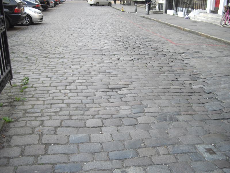
Setted road structure, comprising courses of granite setts of the 1860s and York flagstone pavements with granite kerbstones on the early C19. Later concrete apron around garden not of special interest.
LAYOUT: Charterhouse Square is an irregular pentagon-shaped open space with a central garden and roads on all five sides. All but Carthusian Street, the road running west-east along the south of the square, are laid with a setted road structure which also extends down Rutland Place, down part of Charterhouse Lane and into the carriage arches of the Charterhouse gatehouse and Florin Court. The garden is bounded by cast iron railings and there are three pairs of cast-iron gates leading into the square (two from Carthusian Street on the south side and one from Charterhouse Lane to the north-west). All this ironwork, along with four lamp posts and the bollards outside the Charterhouse lodge, is listed at Grade II as are many of the buildings in Charterhouse Square.
SETTED ROAD STRUCTURE: The structure comprises pavements on both sides of the roads (i.e. around the garden and outside the buildings of the square) with rectangular granite kerbstones and courses of granite setts on the roads themselves. The pavements are paved with large York flagstones except along the stretch outside the buildings on Charterhouse Street where the flags have been replaced with asphalt. They probably date from the early C19, although those around the garden have been narrowed when concrete parking bays were laid. The setts are in a variety of sizes, colours and granite types laid in courses, some of large setts, others smaller, some closely laid, others wide. They are mainly blue or grey, but some are rose-coloured Mount Sorrel granite from Leicestershire. The coursing runs across the road surface changing direction abruptly at the corners. Bands of narrower, closely-set setts run across the two northern corners of the square; these would have been swept and kept cleaner than the larger setts of the road surface and served as road crossings. The granite setts have endured much wear and are pleasingly irregular in surface finish; they contrast in character with the more regular setts of other Victorian streets and may reflect re-use of earlier material. Small areas of end-set paving, possibly of Purbeck stone, survive in front of the western pair of gate piers on Carthusian Street. There have been two major alterations to the setts, both negative changes: the creation of concrete parking bays around the garden which has necessitated the removal of original sets; and the insertion of three speed bumps on the north side of the square. Various repairs have also taken place over the years, of varying degrees of sensitivity to the original fabric, although few have used cement mortar as is commonly found in repaired street surfaces.
HISTORY: Charterhouse Square lies to the south of the monastic foundation from which it takes its name. This C14 Carthusian priory was rebuilt in the C16 as almshouses and a school and is one of the most important surviving buildings of late medieval London. Charterhouse Square itself was laid out in the late C17 and by the Georgian period was a smart address, its central garden criss-crossed with two avenues of trees planted in 1727 and overlooked by terraced houses. Iron railings were installed in 1792, but at this point the roads around the square were laid with broad cobbles, covered with gravel and dirt, and there were no pavements. The earliest surviving photograph of the Charterhouse Square, taken by Valentine Blanchard c1860, show a pavement around the inner side of the square but the road surface is hard to determine. By the time Yorke & Sons photographed the square c1870, the road had been paved with the granite setts that survive today. The setted road structure is thus largely 1860s in date, with a pavement of a few decades earlier. It dates from the major period of resurfacing of London streets in the mid-C19.
Street coverings before the mid Victorian period, where they existed at all, were usually round boulders or large, irregular pebbles. These provided some surface stability but offered little comfort for carriage passengers due to the wide joints in which filth usually collected. In 1824 the engineer Thomas Telford in a 'Report respecting the Street Pavements, &c., of the Parish of St George's, Hanover Square' had recommended laying roads with a foundation of broken stones or concrete upon which should be placed rectangular paving stones of granite, worked flat on the face and straight and square on the sides so as to joint close, grouted with lime and sand. Telford suggested different sized stones for different classes of streets, ranging from 4 to 7 inches wide and 7 to 13 inches long. Transportation of granite was facilitated by the development of the railways and by the mid-century great numbers of London streets were being repaved with stone from Aberdeen, the Channel Islands and the West Country. The Metropolitan Board of Works used Telford's system in many of the new streets they laid out in the 1860s, and their example was followed by parish vestries with whom responsibility for the condition of roads lay. Under the Metropolis Management Act of 1855, responsibility for paving the footpaths and carriageways in Charterhouse Square passed to Holborn District Board of Works, from a trust established by the local Paving Act of 1742. The Board of Works are likely to have instigated the repaving in the 1860s, which was done to a modified version of Telford's specifications. It was common practice to reuse older setts when constructing road surface structure, with worn down setts from busy roads often relayed on quieter thoroughfares; this appears to have happened at Charterhouse Square where the setts differ in surface finish.
REASONS FOR DESIGNATION: The setted road structure in Charterhouse Square is designated at Grade II for the following principal reasons:
* an extremely rare survival of a mid-Victorian road surface in a London square;
* design interest of the different types, colours and sizes of the setts and the irregularity of surface finishes are particularly attractive;
* quality of workmanship required to create an even surface from setts of different size, in particularly where the courses change direction at the corners and the two pathways;
* the early-C19 York stone flags and granite kerbstones of the pavements are more typical, but an integral part of the structure and so included in the designation;
* group value of this strong ensemble which includes Victorian street furniture and listed buildings ranging from the entrance to the Charterhouse and earliest terraced house in the square of c1700 (at Nos. 4-5, behind later facades) to a 1930s Moderne block of flats (Florin Court).
The setted road structure in Charterhouse Square is designated at Grade II for the following principal reasons:
* an extremely rare survival of a mid-Victorian road surface in a London square;
* design interest of the different types, colours and sizes of the setts and the irregularity of surface finishes are particularly attractive;
* quality of workmanship required to create an even surface from setts of different size, in particularly where the courses change direction at the corners and the two pathways;
* the early-C19 York stone flags and granite kerbstones of the pavements are more typical, but an integral part of the structure and so included in the designation;
* group value of this strong ensemble which includes Victorian street furniture and listed buildings ranging from the entrance to the Charterhouse and earliest terraced house in the square of c1700 (at Nos. 4-5, behind later facades) to a 1930s Moderne block of flats (Florin Court).
External links are from the relevant listing authority and, where applicable, Wikidata. Wikidata IDs may be related buildings as well as this specific building. If you want to add or update a link, you will need to do so by editing the Wikidata entry.


Other nearby listed buildings
