Approximate Location Map
Large Map »
Latitude: 51.3803 / 51°22'49"N
Longitude: -2.3587 / 2°21'31"W
OS Eastings: 375128
OS Northings: 164649
OS Grid: ST751646
Mapcode National: GBR 0QH.JGB
Mapcode Global: VH96M.2KCP
Plus Code: 9C3V9JJR+4G
Entry Name: 5, Abbey Green
Listing Date: 12 June 1950
Last Amended: 15 October 2010
Grade: II
Source: Historic England
Source ID: 1394033
English Heritage Legacy ID: 509425
ID on this website: 101394033
Location: Bath, Bath and North East Somerset, Somerset, BA1
County: Bath and North East Somerset
Parish: Non Civil Parish
Built-Up Area: Bath
Traditional County: Somerset
Lieutenancy Area (Ceremonial County): Somerset
Tagged with: Building
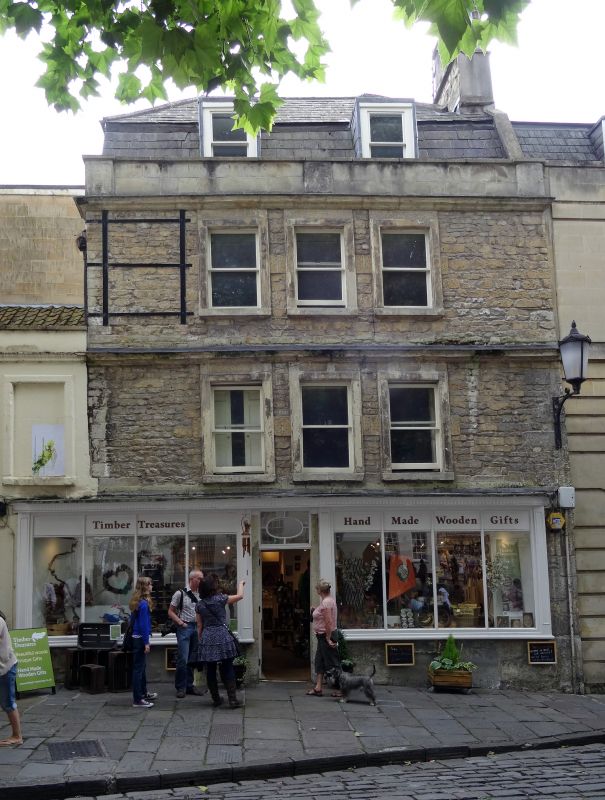
ABBEY GREEN
(South side)
No. 5
12/06/50
GV II
House, now shop with accommodation over. Early C18, altered late C19.
MATERIALS: Bottom courses are Bath limestone ashlar, the rest is limestone rubble, no longer rendered, Welsh slate roof.
PLAN: Double depth plan.
EXTERIOR: Three storeys and attics. Three windows, grouped in middle, with beaded architraves. Late C19 shop front. Door with wood bolection architrave, part glazed, rectangular light over, flanking windows of four panes, divided by narrow timber mullions. Windows above are late C19 plate glass sashes, in dressed surrounds. String course at second floor level. Crowning cornice and parapet, hipped mansard roof in two parallel ranges, two flat-topped dormers, plain sashes, tall ashlar stack with pots to right.
INTERIOR: Not inspected. Ground floor much altered.
HISTORY: This house was probably originally rendered; its rough masonry construction was typical of the generation of builders immediately preceding the arrival of John Wood the Elder in the 1720s. The late C19 alterations may have taken place after the Kingston Estate was sold off in 1874. The western elevation was obscured when the adjoining archway was constructed in 1972. The building has had a varied history. It was the `Raven' public house in c1750, was then occupied by J Cole, corn-cutter, in 1809, and was Holley's fruit shop in 1906.
SOURCES: E. Holland, `The Kingston Estate within the walled City of Bath¿, (1992); Graham Finch, Shop front Record (Bath City Council 1992).
Listing NGR: ST7512864649
External links are from the relevant listing authority and, where applicable, Wikidata. Wikidata IDs may be related buildings as well as this specific building. If you want to add or update a link, you will need to do so by editing the Wikidata entry.


Other nearby listed buildings
