Approximate Location Map
Large Map »
Latitude: 50.3085 / 50°18'30"N
Longitude: -5.2035 / 5°12'12"W
OS Eastings: 171994
OS Northings: 50301
OS Grid: SW719503
Mapcode National: GBR Z4.KQ72
Mapcode Global: VH125.RHGW
Plus Code: 9C2P8Q5W+9H
Entry Name: Milestone Approx 12M West of Dales Yard
Listing Date: 19 October 2010
Grade: II
Source: Historic England
Source ID: 1394844
English Heritage Legacy ID: 508475
ID on this website: 101394844
Location: St Agnes, Cornwall, TR5
County: Cornwall
Civil Parish: St. Agnes
Built-Up Area: St Agnes
Traditional County: Cornwall
Lieutenancy Area (Ceremonial County): Cornwall
Church of England Parish: St Agnes
Church of England Diocese: Truro
Tagged with: Milestone
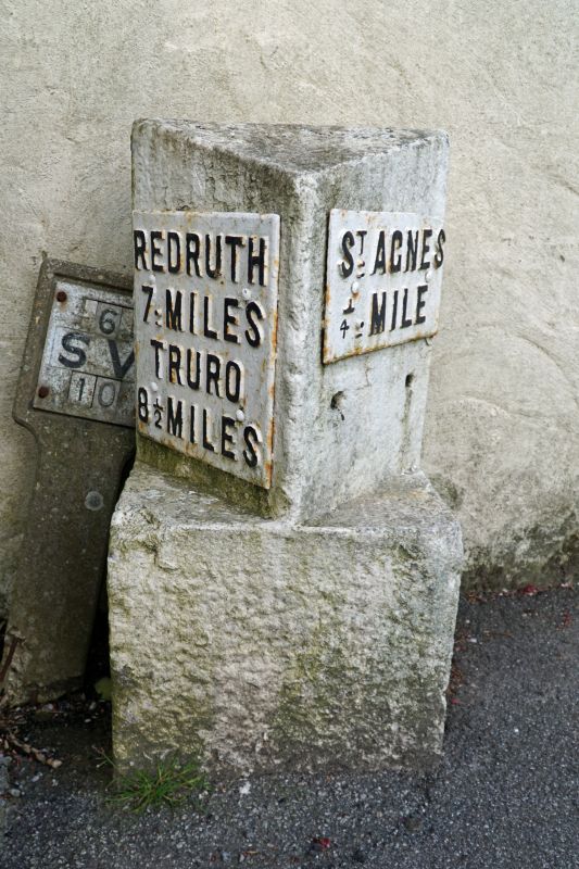
ST AGNES
1536/0/10008 B3277
19-OCT-10 (East side)
Milestone approx 12m west of Dales Yard
II
DESCRIPTION:
The milestone dates from circa 1890, and is of whitewashed stone, with cast-iron plates carrying the inscriptions. It has a square base on plan, the upper section is triangular and the whole stands approximately 0.8m high. To either side are cast-iron plates carrying the inscriptions REDRUTH / 7 : MILES / TRURO / 8 ½ MILES and ST AGNES / ¼ MILE; the lettering is picked out in black paint.
HISTORY:
From the mid-C18 onwards, turnpike trusts were encouraged to provide markers such as milestones and mileposts on the stretches of roads they operated. A former Truro turnpike road ended just to the north of the village of St Agnes. The milestone under consideration was erected in 1890 as one of a very small number by the St Agnes Highway Board on the road through the village which had been made main and adopted by the county, following a recommendation by the Road Committee of Cornwall County Council. The milestone is marked on the 2nd edition Ordnance Survey map of 1907 on the opposite, western side of the road. Anecdotal evidence suggests that it was removed during World War II and reinstated on the opposite side of the road after 1945. It was certainly moved before 1977 to its present location, as it is recorded there on the Ordnance Survey map published in that year. When it was resited, the iron plates giving distances were switched from one side to the other, so that their directions remain accurate.
REASONS FOR DESIGNATION:
The milestone 12m west of Dales Yard in St Agnes, erected in 1890, is designated at Grade II for the following principal reasons:
* Intactness: It is an intact milestone dating from 1890, of an unusually elaborate design for its date
* Rarity: the stone is one of a small number erected by the St Agnes Highway Board on a road adopted as a main route by Cornwall County Council; only three of these stones are known to survive
* Historic interest: it is testament to the continued wave of road improvement throughout the C19, following the widespread C18 development of turnpike roads
External links are from the relevant listing authority and, where applicable, Wikidata. Wikidata IDs may be related buildings as well as this specific building. If you want to add or update a link, you will need to do so by editing the Wikidata entry.


Other nearby listed buildings
