Approximate Location Map
Large Map »
Latitude: 51.3818 / 51°22'54"N
Longitude: -2.3623 / 2°21'44"W
OS Eastings: 374885
OS Northings: 164812
OS Grid: ST748648
Mapcode National: GBR 0QH.9L6
Mapcode Global: VH96M.0JJK
Plus Code: 9C3V9JJQ+P3
Entry Name: The Loft Club
Listing Date: 5 August 1975
Last Amended: 15 October 2010
Grade: II
Source: Historic England
Source ID: 1394908
English Heritage Legacy ID: 510318
ID on this website: 101394908
Location: Bath, Bath and North East Somerset, Somerset, BA1
County: Bath and North East Somerset
Parish: Non Civil Parish
Built-Up Area: Bath
Traditional County: Somerset
Lieutenancy Area (Ceremonial County): Somerset
Tagged with: Clubhouse
656-1/40/1464
05/08/75
SAW CLOSE
(East side)
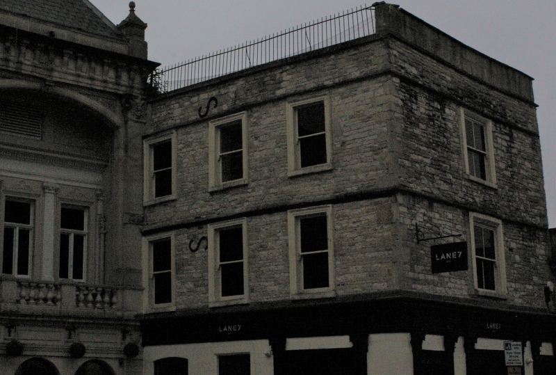
The Loft Club
(Formerly Listed as:
SAW CLOSE Zetters Social Club.
The Regency Public House)
GV
II
Social club, formerly The Regency Public House. Possibly c1670.
MATERIALS: Rubble with ashlar dressings, flat roof, surface not visible.
EXTERIOR: Three storeys. One window front facing west to Saw Close and three window north-facing front adjoining Gala Bingo Club (q.v.) with which this building was formerly associated. All windows are four-pane plate glass sashes: set in raised plat painted stone surrounds on west front, and in painted moulded architraves to north. Ground floor has former late Victorian pub frontages, with fluted wood Corinthian pilasters carrying a full entablature, architrave and frieze broken forward above each pilaster; west front has a large central glazed panel above panelled stall-riser in centre, with panelled door and transom light to right, and former door and transom light to left, divided by six pilasters. North return elevation has a large window between pilasters over a panelled stall-board; to left is a panelled door and transom light; small inserted window in between; entire ground floor has been painted. Upper floors are less extensively altered, and suggest early domestic origins of this building. Weathered drip courses run all round above each level of window heads, with further string course under the ashlar blocking course; rendered parapet to west front, iron railings to northern return.
INTERIOR: Much altered.
HISTORY: This large house stood in the north-west part of the walled city, close to the Timber Close. It has been identified with a house known from the 1670s as the Pound House: Gilmore's map of 1694 identifies it as a cockpit. The area thus has a long continuous history as a place of entertainment. It was subsequently absorbed by the neighbouring theatre to form a Late Victorian group devoted to popular entertainment.
SOURCES: M. Chapman & E. Holland, `The Development of the Saw Close from the Middle Ages', Bath History VIII (2000), 61.
Listing NGR: ST7488564812
External links are from the relevant listing authority and, where applicable, Wikidata. Wikidata IDs may be related buildings as well as this specific building. If you want to add or update a link, you will need to do so by editing the Wikidata entry.


Other nearby listed buildings
