Approximate Location Map
Large Map »
Latitude: 51.3837 / 51°23'1"N
Longitude: -2.3612 / 2°21'40"W
OS Eastings: 374961
OS Northings: 165021
OS Grid: ST749650
Mapcode National: GBR 0QH.3WD
Mapcode Global: VH96M.1H33
Plus Code: 9C3V9JMQ+FG
Entry Name: 43, Milsom Street
Listing Date: 12 June 1950
Last Amended: 15 October 2010
Grade: II
Source: Historic England
Source ID: 1396015
English Heritage Legacy ID: 511426
ID on this website: 101396015
Location: Bath, Bath and North East Somerset, Somerset, BA1
County: Bath and North East Somerset
Parish: Non Civil Parish
Built-Up Area: Bath
Traditional County: Somerset
Lieutenancy Area (Ceremonial County): Somerset
Church of England Parish: Bath St Michael Without
Church of England Diocese: Bath and Wells
Tagged with: Building
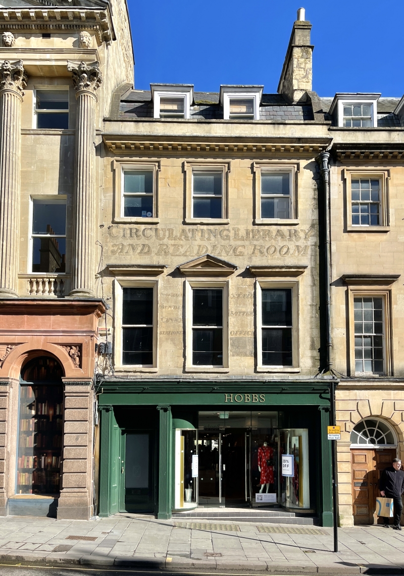
MILSOM STREET
(East side)
No.43 (Formerly
Listed as: MILSOM
STREET (East
side) Nos 43-45
(consec, No.46,
No.47)
12/06/50
GV II
Former house, now offices of Royal Photographic Society. c1765, altered 1980.
MATERIALS: Limestone ashlar, double pitched slate mansard roof with dormers and moulded stacks to right of house.
PLAN: Double depth plan.
EXTERIOR: Three storeys with attics, three-window range. Stepped coped parapet and stopped modillion cornice, eared architraves to second floor windows, first floor windows have lowered sills and moulded architraves, cornices to outer windows and pediment to centre. Plate glass sash windows, painted splayed reveals to first floor with `Circulating Library and Reading Room' painted on wall above, fluted Ionic pilasters flanking C20 door and blocked overlight to left and far right and moulded cornice and fascia over 1980 shop to right. To right good fluted lead rainwater head to lead downpipe.
INTERIOR: Not inspected, but it is entrance to Royal Photographic Society gallery in old Octagon Chapel (qv).
HISTORY: The house possesses a standard elevation, probably by Thomas Jelly; the 1980 shopfront (by Roy Worskett, of the local planning authority) may reuse part (especially the pilasters) of the early C19 shopfront. The painted advertisement is a fairly rare survival, and of interest. SOURCES: (Ison W: The Georgian Buildings of Bath: Bath: 1980-: 146; Colvin H: A Biographical Dictionary of British Architects 1660-1840: London: 1978-: 457; Deposited plans, Bath City Council: 1992-). Finch G: Shopfront Record, Bath City Council: 1992.
Listing NGR: ST7496165021
External links are from the relevant listing authority and, where applicable, Wikidata. Wikidata IDs may be related buildings as well as this specific building. If you want to add or update a link, you will need to do so by editing the Wikidata entry.


Other nearby listed buildings
