Approximate Location Map
Large Map »
Latitude: 51.3829 / 51°22'58"N
Longitude: -2.3613 / 2°21'40"W
OS Eastings: 374952
OS Northings: 164937
OS Grid: ST749649
Mapcode National: GBR 0QH.9TG
Mapcode Global: VH96M.1H1P
Plus Code: 9C3V9JMQ+5F
Entry Name: 14-17, Old Bond Street
Listing Date: 12 June 1950
Last Amended: 15 October 2010
Grade: II
Source: Historic England
Source ID: 1396219
English Heritage Legacy ID: 511622
ID on this website: 101396219
Location: Bath, Bath and North East Somerset, Somerset, BA1
County: Bath and North East Somerset
Parish: Non Civil Parish
Built-Up Area: Bath
Traditional County: Somerset
Lieutenancy Area (Ceremonial County): Somerset
Church of England Parish: Bath St Michael Without
Church of England Diocese: Bath and Wells
Tagged with: Building
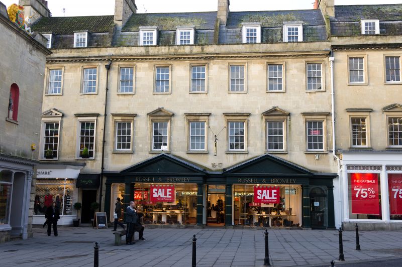
OLD BOND STREET
(West side)
Nos.14-17 (Consec)
(Formerly Listed as:
OLD BOND STREET (West side)
Nos 12-17 (consec),
Nos 18 & 19, Nos. 20 & 21)
12/06/50
GV II
Four houses, part of terrace facing onto a pedestrian way, with shops, now three properties, Used as offices. 1769.
MATERIALS: Limestone ashlar, slate roofs.
PLAN: Double depth properties with mansard roofs, all detailed as typical John Wood domestic terraces.
EXTERIOR: Three storeys, attic and basement, five+three+six windows, all sashes, mostly with glazing bars. Three twelve pane dormers to No.14, and two each to Nos 15,16 and 17, two main floors have sashes in architraves, and at first floor with cornice hoods, plus triangular pediments to bays Nos 2,4,7,10 and 13. No.14 has twelve pane above plain sash. No.15 has twelve above deep fifteen pane, and Nos 16 and 17 have twelve pane at each level, probably original format for terrace. Shopfront to No.14 very bold thirty-six pane double bow with dentil cornice and to deep central doors (1955, by Ernest Tew). Shopfront to No.15, 1982, by David Brain, shopfront to Nos 16 and 17 of 1982; above, a modillion cornice with blocking course and parapet, and five coped party divisions, each with deep rubble and ashlar stacks. Rear elevation not seen.
INTERIORS: Not inspected.
SOURCES: RCHME Report and Survey on No. 14 in National Monument Record, ref. 96985; M. Green, The Eighteenth Century Architecture of Bath (1904), 157; G. Finch, Shopfront Record (Bath City Council 1992).
Listing NGR: ST7495264937
External links are from the relevant listing authority and, where applicable, Wikidata. Wikidata IDs may be related buildings as well as this specific building. If you want to add or update a link, you will need to do so by editing the Wikidata entry.


Other nearby listed buildings
