Latitude: 51.5182 / 51°31'5"N
Longitude: -0.1012 / 0°6'4"W
OS Eastings: 531845
OS Northings: 181631
OS Grid: TQ318816
Mapcode National: GBR P9.FY
Mapcode Global: VHGR0.63CG
Plus Code: 9C3XGV9X+7G
Entry Name: Ramp
Listing Date: 15 February 2011
Grade: II
Source: Historic England
Source ID: 1396459
English Heritage Legacy ID: 494623
ID on this website: 101396459
Location: City of London, London, EC1A
County: London
District: City and County of the City of London
Electoral Ward/Division: Farringdon Without
Parish: Non Civil Parish
Built-Up Area: City of London
Traditional County: Middlesex
Lieutenancy Area (Ceremonial County): City of London
Church of England Parish: St Sepulchre Holborn
Church of England Diocese: London
Tagged with: Building
627/0/10262 WEST SMITHFIELD
15-FEB-11 Ramp
GV II
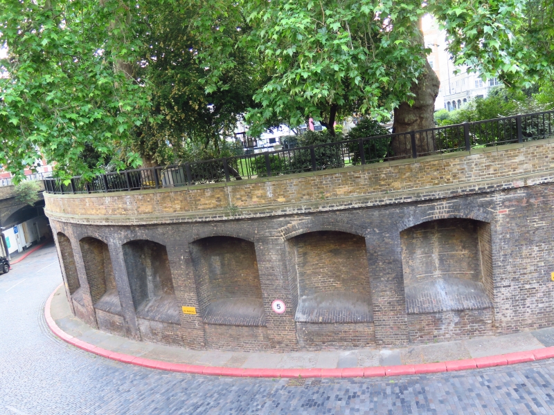
Circular ramp at the centre of West Smithfield providing access to the subterranean goods yard under the Central Market. Designed in 1860, built 1862-5. Later alterations.
MATERIALS: Stock brick retaining walls and paved with courses of granite setts and kerbstones.
DESCRIPTION: The ramp is a circular structure with an outer diameter of 75m, comprising a 10m-wide roadway descending in a spiral from an entrance marked by a wooden kiosk and entrance barrier. The roadway is cobbled with rectangular granite setts, and has a narrow pavement to the inner side with generous granite kerbs on both sides. It curves gently downwards in a clockwise direction, describing almost a complete circuit before ending at three arched entrances to the subterranean former sidings. The central and western arches are set back behind a C20 concrete bridge, supporting the road, and C20 pedestrian stair access. The side walls of the ramp are of stock brick, sections of them being pierced by alcoves with relieving arches, which give structural support. Both the inner and outer walls are topped with low walls in which are set simple railings of later C20 date. The inner wall is of stock brick, the outer of red brick and ashlar.
The modern railings, kiosk, the pedestrian steps, road bridge and an underground lavatory against the outer east side of the ramp lack special interest. The built elements of the park within the centre of the ramp are not included in this listing; the fountain in the park is separately listed at Grade II (q.v.).
HISTORY: In 1860, Parliament passed 'An Act to establish at Smithfields, a metropolitan market for meat, poultry and other provisions'. The Act responded to a Royal Commission of 1849 which identified the problems of accommodating a livestock market in a heavily-populated part of the city. (Dickens had described Smithfield as 'the shameful place ... all asmear with filth and fat and blood and foam'.) The Smithfield Market Removal Act of 1852 relocated the livestock market to Copenhagen Fields in Islington, where the Caledonian Market was opened in 1855. Plans were made for a new wholesale market at Smithfield.
Caledonian Market benefited greatly from its proximity to Camden Station, allowing livestock to be driven straight from cattle trucks into the market. A similar arrangement was therefore proposed for the new Smithfield Market, made viable by the fact that the Metropolitan Railway Company was at that time laying track from Paddington to nearby Farringdon Street. The line - the world's first underground railway - was completed in 1863 under the supervision of John Fowler (1817-1898), the Metropolitan's Engineer in Chief. In 1862-5 Fowler constructed a four-acre subterranean goods station at Smithfield, complete with loading platforms for both the Metropolitan and Great Western Railways. Above it, the new Central Market was built to designs by Sir Horace Jones, opening in 1868. Hydraulic lifts linked the market and the basement goods station and the ramp permitted vehicular access, connecting the goods station to London's roads. The ramp at West Smithfield was an integral part of the development of Smithfield Market from the start. A plan of the proposed site of the market published in June 1860 by the Corporation of London 'shews the proposed inclined Road leading to the Railway beneath the Market', in the form that it was completed.
In 1872 the centre of the spiral roadway was laid out as a circular garden with tall trees and paved paths. The fountain in the middle of the garden, a draped classical bronze figure of Peace by J Birnie Philip (q.v.), was unveiled in 1873. The goods yard remained in use until the 1930s, the station until the 1960s. The area under the market has been used for parking since 1970. The Central Market building was listed in 1972.
SOURCES: The Builder, 29 Dec 1866, pp. 955-6; B. Weinreb et al (eds), The London Encyclopaedia (3rd ed 2008), 842-43.
REASONS FOR DESIGNATION: The ramp at West Smithfield is designated at Grade II for the following principal reasons:
* historic interest: an impressive piece of Victorian civil engineering, necessitated by the emerging need to feed the expanding metropolis, and linked to the world's first underground railway
* materials and craftsmanship: radiating courses of rectangular granite setts laid with great precision by the paviours
* group value: designed of a piece with the Grade II*-listed Central Market and defining a public garden containing a Grade II-listed drinking fountain.
The ramp at West Smithfield is designated at Grade II for the following principal reasons:
* historic interest: an impressive piece of Victorian civil engineering, necessitated by the emerging need to feed the expanding metropolis, and linked to the world's first underground railway
* materials and craftsmanship: radiating courses of rectangular granite setts laid with great precision by the paviours
* group value: designed of a piece with the Grade II*-listed Central Market and defining a public garden containing a Grade II-listed drinking foundation
External links are from the relevant listing authority and, where applicable, Wikidata. Wikidata IDs may be related buildings as well as this specific building. If you want to add or update a link, you will need to do so by editing the Wikidata entry.


Other nearby listed buildings