Approximate Location Map
Large Map »
Latitude: 51.7041 / 51°42'14"N
Longitude: -2.1853 / 2°11'6"W
OS Eastings: 387293
OS Northings: 200611
OS Grid: SO872006
Mapcode National: GBR 1N6.0BJ
Mapcode Global: VH955.2FLH
Plus Code: 9C3VPR37+JV
Entry Name: Cowhill
Listing Date: 14 February 2011
Grade: II
Source: Historic England
Source ID: 1396462
English Heritage Legacy ID: 509066
ID on this website: 101396462
Location: Minchinhampton, Stroud, Gloucestershire, GL6
County: Gloucestershire
District: Stroud
Civil Parish: Minchinhampton
Built-Up Area: Minchinhampton
Traditional County: Gloucestershire
Lieutenancy Area (Ceremonial County): Gloucestershire
Church of England Parish: Minchinhampton with Box
Church of England Diocese: Gloucester
Tagged with: Building
MINCHINHAMPTON
1374/0/10041 TETBURY STREET
14-FEB-11 23
Cowhill
GV II
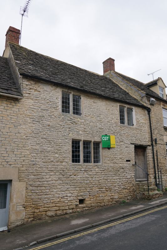
A house in a row, which dates from the later C16 or earlier C17, with alterations in the later C17 or early C18.
MATERIALS: Limestone rubble brought to course, with Cotswold stone slates to the front slopes and concrete tile to the rear. The stack is rebuilt in red brick.
PLAN: The plan has a main range fronting the road, with a short, gabled cross-wing to the rear. The house is of two storeys with a basement, two bays wide.
EXTERIOR: The house is of two storeys with a basement, two bays wide. The ground floor has a three-light, chamfered stone-mullioned window, with two similar windows each of two lights to the first floor. All house metal casements with rectangular leading. A wide doorway to the right of the ground floor is reached by a short flight of stone-built steps. To the rear, the cross-wing has a replacement two-light stone-mullioned window to the gable end, and a small window opening under a timber lintel below. Another two-light window, similar to that in the gable end, is situated in the ground floor of the inner face of the wing. The main range has a shallow, four-centred arched doorway to the left of the ground floor, under a timber lintel. A shallow chute to the right, extending downwards from the first floor, shows externally as a concave, plastered recess under a timber lintel; the purpose of this feature is not clear, but it has been tentatively interpreted as a garderobe.
INTERIOR: The main entrance doorway houses a new double-thickness plank door with regular nail studding, and round-ended strap hinges set on pintles. Internally, the ground floor consists of a single large room to the main range, with an exposed chamfered and stopped beam, and a large inglenook fireplace under a timber bressumer. To the left of the chimney breast, two plank and batten doors set in chamfered, four-centred-arched openings probably dating from the C17, lead to the stairs: a stone winder stair down to the cellar, which has a vaulted ceiling, and a wider timber winder stair rising to the first floor. The rear wing of the ground floor houses the kitchen. To the first floor, the main range is divided into two rooms, in which the roof timbers are exposed. The original trusses are visible within the walls, showing that the roof has been raised from one-and-a-half to two storeys. The trusses are simple A-frames with lapped collars over paired principal rafters; there are staggered twin purlins. The wing to the rear, now housing a bathroom, has an exposed roof structure of similar structure to that in the main range.
HISTORY: Minchinhampton was a medieval settlement developed on a simple cross plan formed by the crossing of the Tetbury to Stroud (now Tetbury Street and West End) road running east-west, and a road running north-south which linked the south of the parish with the Stroud to Cirencester road in the north. The medieval town was centred on the market place, and expanded during the C17 to include the area in which 17 to 23 Tetbury Street now stand. Land which belonged to the Rectory, in the area of Friday Street and Tetbury Street, had seven tenements built on it by 1635, 19 by 1677, and 40 by 1707. Many of the late-C16 and early-C17 houses were probably of one-and-a-half storeys such as those of evidently early date in Friday Street, but many of the C17 houses were rebuilt in the C18.
No. 23 Tetbury Street originated in the C16 as a one-and-a-half storey house, and in common with other houses in the area, its roof was raised to a full two storeys in the following century. At the same time, the house was extended by the addition of a cross-wing to the rear. The footprint of the house is consistent through the Ordnance Survey (OS) map series published between 1885 and 1923. Much of the property owned by the Rectory was sold off between 1809 and 1830. Deeds in the possession of the current owner of No. 23 date back to the ownership of John Crosburn Neal, a farmer from Bradford on Avon; his will of 1864 includes tenements and messuages in Tetbury Street, and the family's holdings in Minchinhampton included land immediately to the east and west of No. 23, as well as the large field to the rear known locally as the Lemon Field, which had also been owned by the Rectory. Deeds in the Gloucestershire Archives show that the site was the property of John Crosburn, a brewster from Minchinhampton; these may pre-date the ownership of John Crosburn Neal. The holdings were sold in 1902 by Neal's heirs to Edmund Kimber, a manufacturer of woollen cloth from Minchinhampton.
SOURCES: Nigel Paterson, Gloucestershire Buildings Recording Group Notes on 23 Tetbury Street, Minchinhampton (2009)
A History of the County of Gloucester (Victoria County History) Volume 11: Bisley and Longtree Hundreds (1976), 184-90
REASONS FOR DESIGNATION: 23 Tetbury Street is listed at Grade II, for the following principal reasons:
* Architectural interest: the building is a well-preserved C16 town cottage with C17 alterations and additions
* Intactness: the house retains its plan form unaltered, and has some good C17 joinery
* Group value: with the adjacent row of cottages, and the large number of other listed buildings to either side of Tetbury Street
23 Tetbury Street, a town cottage in a row, dating from the C16 with alterations in the C17, is designated at Grade II, for the following principal reasons:
* Accuracy: the building was previously listed as part of a row of adjacent cottages dating from the C18, but it is quite different from these neighbouring buildings, and its special interest will be better reflected in its own separate list entry
* Architectural interest: the building is a well-preserved C16 town cottage with C17 alterations and additions
* Intactness: the house retains its plan form unaltered, and has some good C17 joinery
* Group value: with the adjacent row of cottages, and the large number of other listed buildings to either side of Tetbury Street
External links are from the relevant listing authority and, where applicable, Wikidata. Wikidata IDs may be related buildings as well as this specific building. If you want to add or update a link, you will need to do so by editing the Wikidata entry.


Other nearby listed buildings
